SUMMARY
Summary
The Prince George’s County Five greenway is a 17-mile stretch of the East Coast Greenway that runs through the heart of upper Prince George’s County. It connects five areas of interest that promote the unique identities of upper Prince George’s County for the enjoyment, education, and recreation of all users, locally and regionally. By designing for users of all ages and abilities, this path increases accessibility to an already highly-traversed area, catalyzes the economic development of the community, and helps educate the public on a
wide variety of topics including science, wildlife habitat, agriculture and cultural history.
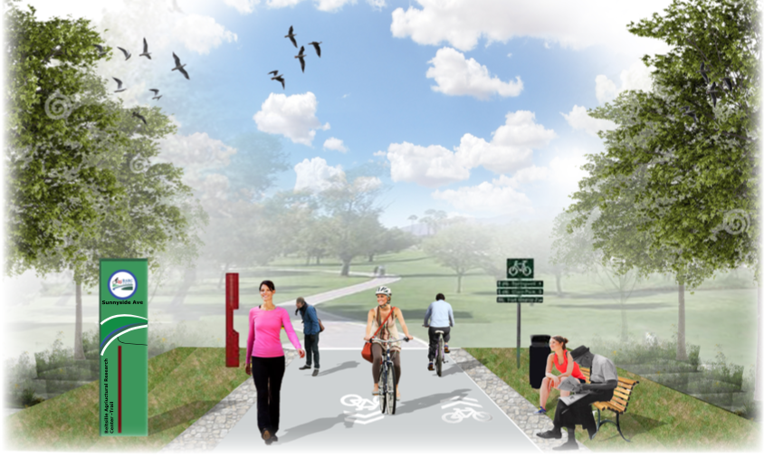
This report details the path alignment and greenway master plan connecting Bowie State University and the Indian Creek Trail in Beltsville. Several routes were examined and multiple alternatives are presented in this master plan, the resolution of which depends on further stakeholder input. The recommended path alignment maximizes the use of existing infrastructure to accommodate both pedestrians and bicyclists in a safe and comfortable environment.
Furthermore, the trail was designed in accordance with the trail design policies published by the East Coast Greenway and MNCPPC. It meets the trail construction standards established by NACTO and AASHTO including traffic separated trail systems, firm surfaces that are easily navigable by touring bicycles and/or wheelchairs, public accessibility (physically and financially), integrated recreation and transportation infrastructures, avoidance of steep grades, safe traffic volumes and noise concerns, public safety, and responsivity to modern design thinking.
It has been shown that one of the easiest, most economical, and environmentally-friendly actions to revitalize a community is through the introduction of a trail system. At a relatively low cost, the introduction of the greenway to upper Prince George’s County is expected to boost tourism and economic growth in the associated communities by supporting local businesses, stimulating development projects, increasing jobs, and improving other socio-economic factors of the community. It represents a critical connection between multiple trail systems and provides accessibility to a valuable, yet somewhat isolated area of the county.

Master Plan
The Prince George’s County Five areas of interest were selectively chosen for the special characteristics and opportunities they offer to the trail. The design team made contact with Robert Patten, who had the original vision for this project. It was with Robert Patten that the design team determined the areas to focus on for this first design phase of the trail. Prince George’s County cannot be described without mentioning Bowie State University and City, the Patuxent Research Refuge, NASA Goddard Space Flight Center, the Beltsville Agricultural Research Center, and the historic city of Greenbelt. These five areas were deemed priority because of the fantastic melody they create. It is a perfect blend of not only science, agriculture, and education, but also community, culture, and recreation. The path through these five invaluable areas offers a mix of rural, urban, and suburban environment for the user. The purpose of this project was to expand the East Coast Greenway while promoting the unique identities of Prince George’s County by defining connections for user enjoyment, education, and recreation.
Objectives
-
Defining major/minor trails for the East Coast Greenway and creating a “sense of place”/image for the particular trail routes
-
Determine evaluation criteria for project success at the conceptual level
-
Determine construction standards
-
Creating opportunities for economic growth in PG County, including easy access to different recreational activities, food/drink amenities, and showcasing historical areas
-
Providing environmental/ecological experiences that are easily accessible for the public but nondestructive to the various ecosystems
-
Providing easy access to different site amenities throughout the trail system using trail extensions/subpaths, trail heads, wayfinders, trail markers, informational kiosks etc.
-
Providing a comfortable pedestrian/bicyclist environment using safe bicycle-lane procedures, speed/volume management techniques, appropriate signage and lane markings, separations from vehicular traffic, safe intersection crossings, and lighting fixtures
-
Providing trail amenities for public use, such as furniture, comfort stations, gathering areas, and public parking
-
Creating a trail using sustainable practices and having a “light touch” on the land
-
Creating a list of stakeholders for the client
-
Determine materials that will be used on the trail and their subsequent environmental impact on the project’s ecological footprint
SITE ANALYSIS
Site Analysis
The Prince George’s County Five has arisen due to the demand for safer pedestrian and bicycling travelways for the highly active community of Prince George’s County, as well as the desire to connect the northern Prince George’s County trails of the East Coast Greenway with those within Washington D.C. area. This greenway would provide for a high level of connectivity and access to various existing trail systems and communities and improve safety for all users — regardless of age or ability.
This extensive means of transportation would promote educational and recreational experiences for the public, whilst being nondestructive to the various environmental ecosystems throughout the trail route. It would also encourage community members to walk or bike to work, encourage family outings/adventures, and spur the economic growth of the community. The benefits to such a proposition of a greenway are endless, especially to a community as a whole.
The greenway’s design was treated as five different areas
of interest, each with its own unique characteristics and “sense-of-place,” which had to be extensively researched. These areas included the City of Greenbelt, the Beltsville Agricultural Research Center (B.A.R.C.), NASA Goddard Space Flight Center, the Patuxent Research Refuge, and Bowie State University and City. Each team was responsible for the design of their respective area: determining its configuration, signage and furniture, various connections, etc. Many opportunities were presented, however,
there were various constraints, largely site-related, that determined its recommended configuration.
The design team as a whole began by researching various aspects of the region including topography, hydrology, soils, habitat, wildlife, land use and zoning, and existing transportation systems. The proposed pathways are also required to follow current construction standards and guidelines as set for by the American Association of State Highway and Transportation Officials (AASHTO) and the National Association of City Transportation Officials (NACTO), which will be presented at the end of this report. The team then presented their preliminary findings to a group of experts representing MNCPPC and regional stakeholders of the area to refine their design thinking. After careful deliberation and meetings with even more stakeholders, the result is a carefully planned design that takes a multitude of factors into consideration.
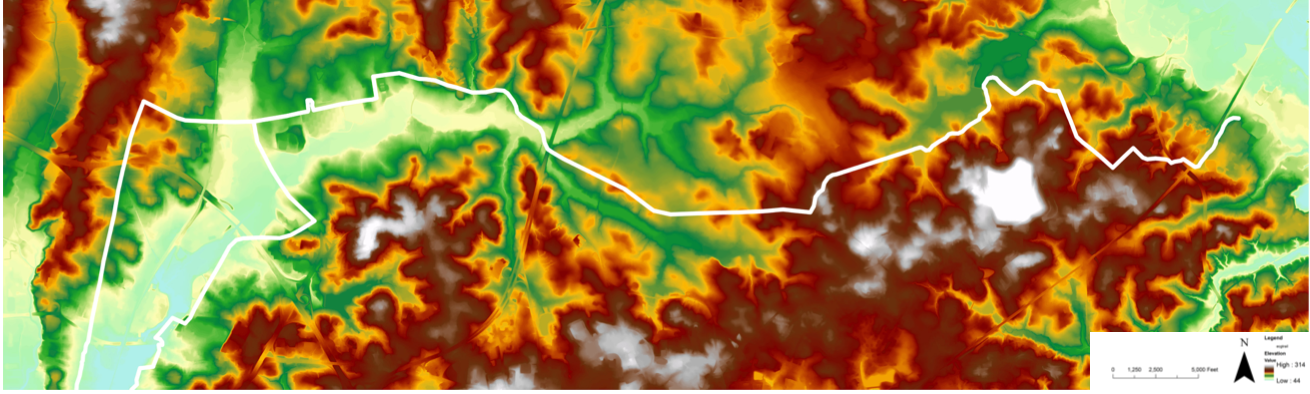
Elevation
Opportunities on Site
The site, a new addition to the East Coast Greenway, encompasses a 17- mile stretch spanning from Bowie State University to nearby Greenbelt. The low point on site is 46 feet above sea level, located near Greenbelt, while the high point is 312 feet above sea level, located close to the Patuxent Research Center. This is a 266-foot change in elevation, which will impact the chosen location of the trail, so as to not create an area where the trail is too steep to navigate.
In terms of opportunities on our site, several of the low areas run alongside a stream which could be an attraction for pedestrians along the trail. Similarly, the higher elevations on site run through forested areas which can serve as a more secluded and intimate way to connect with nature. Although the trail elevation changes by several hundred feet, it is over a long enough distance that the slope will not be a great concern. In areas, like Greenbelt or the untraversed trail in Patuxent careful bike path planning must be considered.
Costs of Designing Through Steep Slopes
The change in elevation on site will play a role in determining where the trail will run as well as which material should be chosen to best suit the trails’ needs. As has been stated, the slope is gradual over the course of the 17 miles; however, some of the proposed trail sections might need to be re-routed to better accommodate a shallower slope for all users.
Along with general user comfort, economic cost is another reason why
a trail might have to be re-routed, usually making the trail longer than desired. In areas where the slope is a little bit steeper, different materials might have to be considered, oftentimes making the cost increase. Excavation in areas with steep slopes are a larger risk than shallowly sloped areas; thus, also increasing the price. Maintenance in steeper areas, as well, is an extra cost due to the difficulty of navigating different terrains with different vehicles. Safety, ultimately, is the main concern, and to ensure that everyone remains safe during construction and for the future path, the path of least sloping resistance should be chosen.
Pedestrian Safety and Accessibility
The map indicates general topography on site with higher areas being indicated by a white or red color and low areas being shown in green and light blue. Grade change on site is not a drastic concern
but trail distance to vehicular access and emergency services may be an issue. Thus, it may be wise to design a wider trail in areas where roads and parking areas are not as close. While all parts of the trail may not be regularly used by pedestrians, it is important to consider ADA requirements, which may lead to designing the trail with materials on which all pedestrians can travel on.
Hydrology
Floodplains
The Federal Emergency Management Agency (FEMA) identifies a flood hazard area as a Special Flood Hazard Area (SFHA). SFHA is defined as the area that will be inundated by the flood event having a one percent chance of being equaled or exceeded in any given year. The one percent annual chance flood is also referred to as the base flood or 100-year flood.
SFHAs are labeled in zones, and the East Coast Greenway Floodplain is located in Zones A and AE. Zone A is characterized by areas subject to inundation by the 1-percent-annual-chance flood event, generally determined using approximate methodologies. Zone AE is characterized by areas subject to inundation by the 1-percent-annual-chance flood event determined by detailed methods.
Coastal flooding affects tidal bodies of water, including the tidal reaches of the Patuxent River in Prince George’s County. The Prince George’s County Department of the Environment also recognizes and manages riverine flood hazard areas, identified as vulnerable to flooding from the one percent annual chance flood (100-year floodplain) as shown on the county’s Flood Insurance Rate Map prepared by FEMA’s National Flood Insurance Program. Beaver Dam Creek and the Western Branch of the Patuxent River are both recognized in the management program by the county.
Streams
The proposed trail system has five major stream systems located in the corridor. These include the Patuxent River, Beaver Dam Creek, Indian Creek, Beck Branch, and the Paint Branch. The largest and most influential of these systems is the Patuxent River, which offers many amenities to trail users such as kayaking, canoeing, boat ramps, campsites and pavilion rentals, classes and activities, education, fishing, hunting, and birdwatching.
The Indian Creek Trail offers users access to Lake Artemesia and serves as a link to the town of Berwyn Heights, Maryland. The trail runs entirely through dense woodlands, providing an abundance of shade and making this trail slightly cooler than others in the humid summer months.
The Paint Branch connects directly with Indian Creek and Lake Artemesia. The trail system connects users to the University of Maryland after crossing US 1 and soon after the trail reenters a heavily-wooded landscape, passes under University Boulevard/ State Route 193 and skirts the edge of the Paint Branch Golf Course. The final section of the trail extends north to Cherry Hill Neighborhood Park.
Beaver Dam Creek and Beck Branch are both stream systems in mostly rural settings. They run along the Beltsville Agricultural Research Center property and offer seasonal fishing and beaver habitat.

Lakes
Four lake bodies surround the proposed trail and will be of interest to users: Lake Artemesia, Cash Lake, Lake Redington and Greenbelt Lake. Lake Artemesia has a public park with handicap- accessible trails and fishing piers, as well as aquatic gardens. Hiking and biking trails surround the Lake. Trails are also available to connect users to College Park Airport and Aviation Museum.
Greenbelt Lake has a 1.4 mile trail loop good for all skill levels. The lake is primarily used for hiking, walking, running and fishing. Leashed dogs are also welcome. Bathrooms, picnics areas, and water fountains are also available.
A 1.4 mile trail travels along the edge of Cash Lake, the largest impoundment at Patuxent Research Refuge. This trail offers many opportunities to view the lake and its waterfowl, as well as a beaver lodge and evidence of their activity. There is also a seasonal fishing program at Cash Lake, with fishing by permit from the accessible pier and along parts of the shoreline.
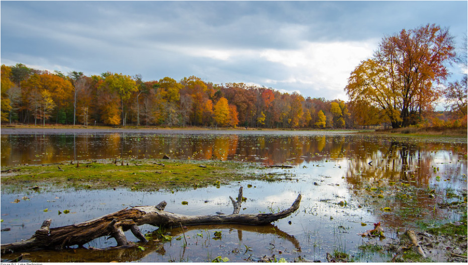
The Loop Trail is a 0.3 mile paved and fully accessible trail. It leaves the Patuxent Research Refuge Visitor Center and offers views of both Lake Redington and Cash Lake. Plantings inside the loop offer a demonstration of the PEPCO power line right-of-way management program, meadow management, and a mitigation wetland.

Soils
Prince George’s County and Soil Type
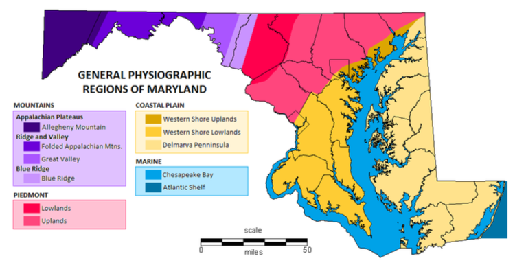
Prince George’s County is found on the Coastal Plains, specifically the Upper Coastal Plains or Western Shore Uplands. The Atlantic Coastal Plain Province is underlain by a wedge of unconsolidated sediments including gravel, sand, silt, and clay, which overlaps the rocks of the eastern Piedmont along an irregular line of contact known as the Fall Zone. It is called the Fall Zone or Fall Line because of the presence of rapids and falls where it is crossed by rivers and streams, such as at Great Falls along the Potomac River. Eastward, this wedge of sediments thickens to more than 8,000 feet at the Atlantic coast line.
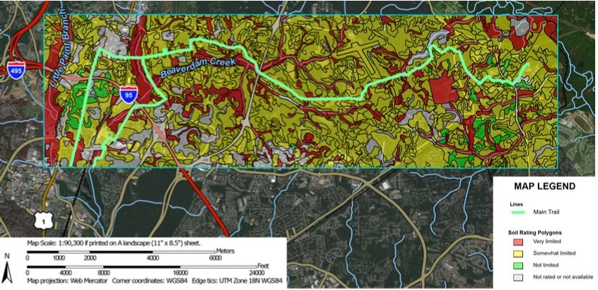
The maps chosen to best represent soils were soils in terms of paths and trails, hydrologic soils, and drainage class.
Paths and trails show where a path or trail would be easily implemented and where one would be very limited to implement based on the soil information from the USDA Web Soil Survey.
Hydrologic soils and drainage class are different drainage groups for soils but can differ greatly in the information they convey. Hydrologic soils estimate runoff potential while drainage class shows how well- drained an area is. Drainage class can also be dependent on slopes, where larger slopes can lead to a well-drained area in usually poor soils, whereas hydrologic soils are based solely on soil composition.

Paths and Trails
The ratings are based on the soil properties that affect trafficability and erodibility. These properties are stoniness, depth to a water table, ponding, flooding, slope, and texture of the surface layer.
• Red means the soil is rated as very limited to work with in terms of building paths and trails in those areas. Many of the red areas are around streams like Beaverdan Creek and other bodies of water.
• Yellow is the most common zone and means that a good por- tion of the site is rated as somewhat limited.
• There are only a few green areas where building paths and trails are not limited. These areas are primarily found in urban areas, in the west it is around Greenbelt and to the east it is around Bowie University.
HABITAT
Habitat
According to the Food and Agriculture Organization of the United Nations, a forest is “land spanning more than 0.5 hectares with trees higher than 5 meters and a canopy cover of more than 10 percent, or trees able to reach these thresholds in situ. It does not include land that is predominantly under agricultural or urban land use.” 0.5 hectares is equivalent to 1.23553 acres or 53819.6868 square feet. There is 436957531.4 square feet of canopy coverage in our site boundary. This is equivalent to 10031 acres of canopy coverage which then converts to 4059.5 hectares.
Our site contains a significant amount of canopy as described above. Our design will be aimed to minimize the amount of canopy coverage lost, this will be a challenge for portions of the trail that go through heavily wooded areas. The hydrology of the site is not barren; canopy coverage buffers the stream and lakes. Surprisingly, the protected parks of the site lack canopy coverage, due to clearing for recreational activities.
Relating to habitat, there are many potential areas for wildlife to occupy as well as migrate. Our site includes the Indian and Beaver Dam Creek, both perfect examples of natural corridors for wildlife. The canopy of the site is fluid in some areas, while also being fragmented in other areas. Unfragmented habitat is import- ant for wildlife. Man-made edges of habitat are normally straight cut, which causes complications for wildlife. Certain animals and plants need natural edges of forest in order to survive. Biodiversity is at stake when forest patches become too small or too fragment- ed to surrounding forest. Human-made edges sometimes allow for the introduction of invasive species, the increased frequency of fires, increase in predation, and increase in pollution infiltration.

Wildlife
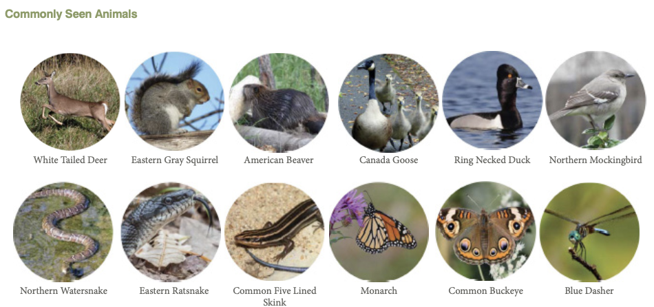
Patuxent Research Refuge
Patuxent Research Refuge is a key area along our trail for wildlife. There are a variety of protected habitats here and it is an excellent destination along the trail for people to learn about and view wildlife.
Trails in this region should be carefully designed in order to minimize disturbance to wildlife and highlight educational opportunities.

BOWIE HERITAGE TRAIL

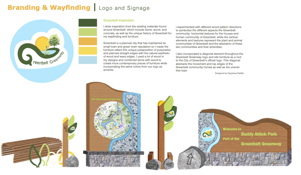
Mission Statement, Branding & Wayfinding
The Bowie Heritage Trail will connect communities, highlight Bowie’s history, and bring people closer to nature. The trail aims to highlight Bowie University, the state’s oldest historically black college, and connect the college with Old Town Bowie and neighboring communities. Being a destination along the East Coast Greenway will attract visitors to Old Town Bowie and revitalize the historical railroad community. The greenway will connect people to nature and transform underutilized green space into beautiful, accessible parks and trails.


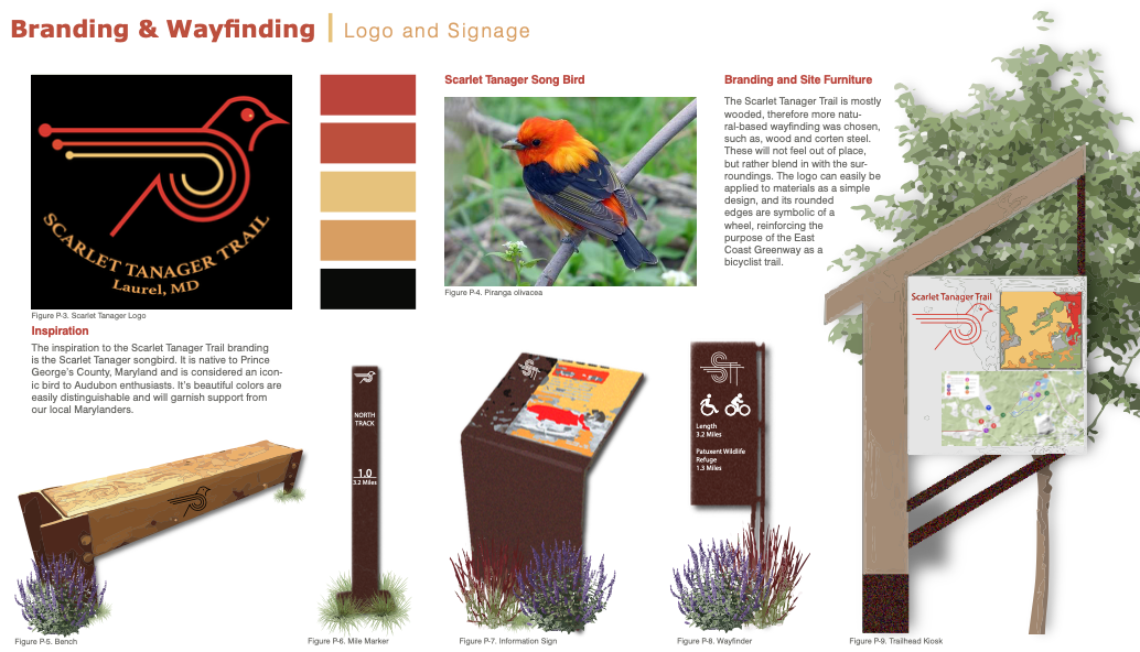
SCARLET TANAGER TRAIL
The Scarlet Tanager Trail
The Scarlet Tanager Trail is a unique part of the greater East Coast Greenway that runs through Prince George’s County. This trail shows off a side of the county that most people do not get to see. It will take users away from busy streets and into the woods, allowing patrons an escape from the businesses of nearby Washington D.C. It takes users through agricultural fields, past an abandoned landing strip, and towards the Patuxent Wildlife Refuge Visitor Center.
As part of the Patuxent Refuge section of the trail, it is suggested that the Scarlet Tanager Trail connect with the Patuxent Research Refuge Visitor Center’s tram route. By making this connection, trail users will be brought directly to the Visitor Center and will have the chance to learn about what is being done at the Research Center. This will also allow users access to spectacular views of Cash Lake and Lake Redington, as well as, wildlife throughout all seasons. The trail would then continue along the maintenance road to the east and connect to Old Laurel Bowie Road.
The proposed trail is minimally invasive, as no new construction is needed. The pathways are already paved or cleared to create a smooth surface. These existing surfaces should require low maintenance.
If the Visitor Center does not wish to permit bike use on the premises, there are two other suggested routes: connecting with the tram route in the same location as the original proposed route but heading east away from the Visitor Center, or creating a new trail that borders the property line
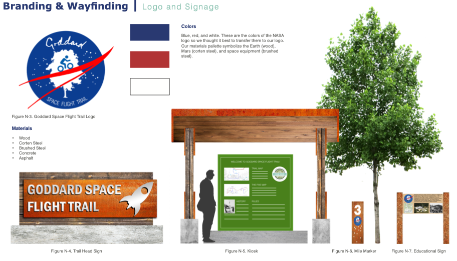
GODDARD SPACE FLIGHT TRAIL
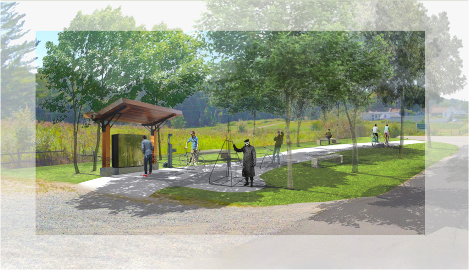
Site Plan
Our site is east to the historic Greenbelt community, and west from the Patuxent wildlife refuge. Our site has a significant amount of canopy coverage and pervious surface. Our trail spans approximately 4.2 miles from Beaver Dam Rd to Frankfort Dr.
Goddard Space Flight Center
NASA’s Goddard Space Flight Center in Greenbelt, Maryland, is home to the nation’s largest organization of scientists, engineers and technologists who build spacecraft, instruments and new technology to study Earth, the sun, our solar system and the universe. Goddard is also home to Hubble operations and the upcoming James Webb Space Telescope.
Goddard manages communications between mission control and orbiting astronauts aboard the International Space Station. Goddard scientists stare into the sun, grind up meteorites for signs of life’s building blocks, look into the farthest reaches of space, and untangle the mysteries of our own changing world. Goddard engineers construct sensitive instruments, build telescopes that peer into the cosmos, and operate the test chambers that ensure those satellites’ survival.
The first Sunday of every month Goddard conducts model rocket launches with model rocket kits available for purchase on site. There are also 7 permanent exhibits at the Visitor Center.
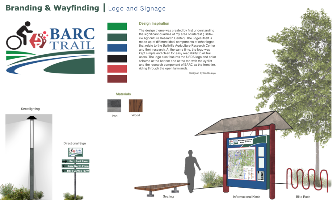
BARC TRAIL
Introduction
The Beltsville Agricultural Research Center (BARC) is over 7000 acres, divided into experimental pastures, or chards, gardens, fields, and woods. It is located in Beltsville, Maryland and lies north of the Capital Beltway, between Interstate 95 and Route 295 (the Anacostia Freeway). The BARC area is a part of the Agricultural Research Service, the main research agency of the U.S Department of Agriculture. The Agricultural Research Services conducts research here to discover solutions to agricultural problems of high national priority and to disseminate this knowledge. They seek to ensure the production of high quality, safe food and other agricultural products, assess the nutritional needs of Americans, sustain a competitive agricultural economy, enhance the environment, and provide economic opportunities for rural communities and society as a whole..
The BARC Trail is an important connection with the proposed alignment of the Greenway because of its unique educational values, view qualities in the different landscapes, and mainly because it is at the center of connection to the other areas of interest like the city of Greenbelt and the Goddard Space Flight Center.
Objectives
-
Safety and standards
-
Areas of interest
-
Accessibility
-
Identity
-
Educational stops and wayfinders
-
Provide Deliverables
GREENBELT GREENWAY

The Greenbelt Greenway
Most cities grow gradually over time but Greenbelt has the unique history of being one of the three ‘green towns’ that was planned and built in 1936. It was built from scratch over just a few years on what was once farmland as part of President Franklin D. Roosevelt’s New Deal Initiative.
There are many unique sights to see and places to visit within historic Greenbelt. At the heart of the city is the Roosevelt
Center, which offers shops, restaurants and an open courtyard for visitors to rest. The Old Greenbelt Theater is also located in close proximity to the Roosevelt Center. Not a block away, is the historic Greenbelt Community Center and the Greenbelt Museum, located just across the street. In addition to the historical part of Greenbelt, visitors can enjoy the natural parts of Greenbelt at Greenbelt Lake and Buddy Attick Park.
Running through Greenbelt will be the Greenbelt Greenway trail, which will be an optional loop off of the main trail of the Prince George’s County Five. While Greenbelt is optional, it offers unique and diverse opportunities for the community of Greenbelt itself, as well as trail users who are looking to learn more about its history and experience the natural areas within and around Greenbelt.
In addition to offering a variety of historic and natural experiences, the Greenbelt Greenway will also connect visitors to different areas associated with Greenbelt and other nearby trails. The Greenway will connect from the northwest through Cherrywood Lane, while the north will connect up to the Beltsville Agricultural Research Center. To the southeast the trail will connect to Greenbelt Road(193) and the NASA Goddard Space Flight Visitor Center. The final connection to the south from Greenbelt Lake will also take visitors on to Greenbelt Road, but will go west to Greenbelt Park, which is managed by the National Park Service and offers, trails, picnic areas, and campsites.
Overall, the Greenbelt Greenway offer a variety of experiences unlike any other on this trail. Whether you want to take a stroll through Buddy Attick Park or catch a movie at the historic Greenbelt Theater, this trail has something to offer trail users of all ages and abilities, and would be a sorely missed opportunity were it not implemented.