SUMMARY & GOALS
Executive Summary
The Carroll Creek Wildlife Recreation Area conceptual plan is the result of a collaboration between The City of Frederick Planning Department, the Partnership for Active Learning in Sustainability, and a team of graduate students in Landscape Architecture at the University of Maryland . The design team was asked to prepare a detailed site analysis of the Carroll Creek floodplain between Highland Street and the Monocacy River and to develop a conceptual design for a shared use (bicycle and pedestrian) path that would connect existing infrastructure through upcoming development in East Frederick to the future Monocacy River Trail.
The City of Frederick has been actively planning for bicycle transportation and walkability since 1990. An existing plan calling for Shared Use Paths that link major city, state and national trails is in place. This report proposes a conceptual design for the Carrol Creek Wildlife Recreation Area, a Shared Use Path and greenway that will serve as an important link in this network.
The conceptual design interweaves Carroll Creek, historic and future neighborhoods, the fairgrounds, parks, wildlife, and the floodplain in order to meet the project goals:
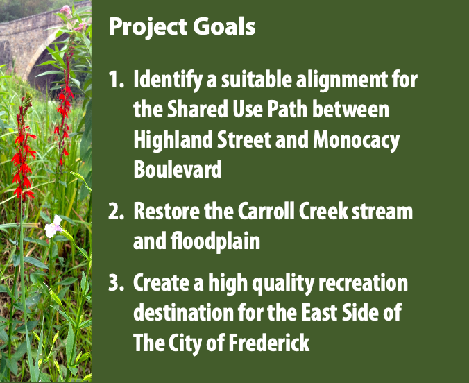
The multifaceted plan proposed here includes trails, habitat, places to play, and areas to discover. The alignment of the Shared Use Path not only connects Highland Street and Monocacy Boulevard, but also links newly developing neighborhoods, parks, forest, a historic cemetery and the Monocacy River. The restoration of the Carroll Creek floodplain ecology provides a crucial wildlife corridor to the the Monocacy River, creates a resilient flood control system that protects homes and businesses, and brings nature into a rapidly urbanizing area. The varied paths and way stations create opportunities for multifarious recreational and educational experiences.
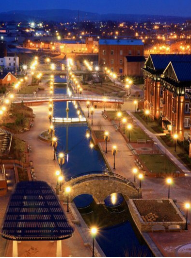
The City of Frederick has transformed the downtown section of Carroll Creek from a flood hazard into an iconic cultural and recreational destination. The proposed Carroll Creek Wildlife Recreation Area is a culmination of this metamorphosis—a hiking and biking gateway to the historic downtown, the Monocacy River, and, ultimately, the District of Columbia and the Catoctin Mountains. By connecting local and regional destinations, the Carroll Creek Wildlife Recreation Area will enhance quality of life and serve as a cultural, ecological and economic asset for The City of Frederick.
SITE ANALYSIS
Habitat
The City of Frederick and the Carroll Creek Watershed are located in the Piedmont physiographic region. The Piedmont is characterized by mixed hardwood forests, swift swift-running rivers and streams, mountain laurels, ferns and grasses, low mountain chains and isolated hills of hard rock forming broad valleys covered by clay soils. Piedmont valleys and streams are home to a dizzying array of fish and wildlife.
The study area along Carroll Creek is considered “hydrosere” habitat, which consists of floodplains and wet bottomlands. Tree species that occupy these wet bottomlands include silver maple, sycamore, hickory, white oak, box elder, hackberry, sweet gum, and green ash . Pawpaw, poison ivy, wild grape, wild azaleas, witch hazel and spicebush thrive on the forest floor. Piedmont wetlands in the hydrosere support some of the largest communities of insects, crustaceans, mollusks, fish, amphibians, reptiles, birds and mammals in the Chesapeake region . Although only making up 5 percent of the Piedmont, hydric habitats are the Piedmont’s most intense and diverse life systems.
According to a 2012 Maryland Department of the Environment (MDE) report, Carroll Creek is among the approximately 61 percent of stream miles in the Lower Monocacy River Basin that are biologically impaired by sediments, nutrients, fecal bacteria and impacts to biological communities.Based on sampling pollution-intolerant bugs in Carroll Creek watershed streams, 40 percent of samples scored good or fair, while 60 percent scored poor or very poor . Relative to physical habitat: 10 percent sampled streams scored good, 70 percent scored fair, and 20 percent scored very poor. Relative to erosion: 10 percent of the stream banks studied showed no sign of erosion, 30 percent were mildly eroded, 30 percent were moderately eroded, and 30 percent were severely eroded.
Due to relatively poor habitat conditions, the Carroll Creek watershed has the least diversity of fish species of all creeks assessed in the Lower Monocacy River watershed. Even fish that are stocked in Carroll Creek have difficulties reproducing. For example, Carroll Creek near Route 15 is managed as a put-and-take fishing area. Each year, this part of the creek is stocked with adult rainbow trout, and while these fish survive, no reproduction occurs.
Some basic restoration measures along Carroll Creek, such as reforesting its banks and constructing wetlands in hydric soils, will improve water and habitat quality. Streamside trees and logs help shape the stream channel and create pools and slow-water areas better suited for aquatic species.
Maryland’s Wildlife Diversity Conservation Plan recommends several actions for protecting and restoring the state’s wide diversity of fish and wildlife. The following recommendations from the plan should be applied to the installation and ongoing maintenance of Carroll Creek Wildlife Recreation Area:
• Restore and protect riparian buffers;
• Limit impervious surfaces in watersheds;
• Improve stormwater management;
• Encourage reforestation within the watershed;
• Preserve and enhance connectivity of critical habitats;
• Educate the public about stream conservation and “Greatest Conservation Need” species; and
• Restore wetlands


Floodplain
A Degraded Carroll Creek Floodplain
A floodplain is low-lying ground adjacent to a river or stream that is periodically inundated by water . Healthy floodplains support high levels of biodiversity and are some of the most productive ecosystems on Earth . They are also extremely valuable economically in terms of the services they provide to society, including reduction of flood risk and support for highly productive fisheries . Despite these attributes, floodplains are among the most converted and threatened ecosystems and have recently become the focus of conservation and restoration efforts across the United States and globally.
The Carroll Creek floodplain was once healthy and provided the ecosystem services described above. However, these services began diminishing as the land was cleared for timber and agriculture. All across the Piedmont, much of the landscape was farmed out and abandoned by 1800, only to be later reclaimed by subsequent generations, who would then clear the second-growth forests and farm again.
The floodplain of the proposed Carroll Creek Wildlife Recreation Area has likely been through many such cycles, and it is still being farmed and used as pasture. Today it is in the middle of housing developments being proposed to accommodate an ever-growing population of The City of Frederick. As a result of past and current human activity in the Carroll Creek floodplain, the ecosystem services it provides are greatly diminished.

A Restored Carroll Creek Floodplain
Restoring the Carroll Creek floodplain is key to the creation the Carroll Creek Wildlife Recreation Area. A restored floodplain would provide shade to visitors walking or biking in reforested riparian buffers flanking
the creek. Visitors would look out over acres of dynamic wetlands teeming with wildlife. Biodiversity created by native plant communities supporting insects and amphibians will bring keystone species like bald eagles and graceful birds like great blue herons back to the area, providing wildlife viewing opportunities for families. Interpretive signage about these and other benefits will draw teachers and their students.
A restored floodplain’s regenerated forest canopy would calm the force of rainwater while new wetlands absorb floodwaters, helping to keep the basement of nearby homes dry. Continuing to allow periodic inundation of the restored floodplain by the Monocacy River’s backup flooding will rework the landscape’s surfaces, creating a shifting mosaic of diverse habitat patches able to support a great diversity of fish and wildlife. A restored floodplain will bring with it these and other aesthetic benefits, while providing critical ecosystem services that will help keep people safer, the water cleaner and the fishing better.


Drainage
Monocacy River Watershed
To better understand the drainage context of the study area it is important to examine how it relates to the bigger picture and the contributing factor it plays in the health of the Chesapeake Bay.
The City of Frederick is located within the 512,00-acre Monocacy River watershed, the largest contributor to the Potomac River. The drainage area can be broken down into the Upper and Lower Monocay River watersheds. The study area is located entirely within the Carroll Creek watershed, a sub-watershed of the Lower Monocacy River watershed.

Carroll Creek Watershed
The Carroll Creek watershed encompasses a 10,872-acre drainage area bound on the west by the Catoctin Mountains and on the east by the Monocacy River . The two main tributaries in the watershed are Rock Creek and Carroll Creek . Both streams originate in the wooded foothills of the Catoctin Mountains where they flow through a mix of agricultural and residential areas . They merge near U .S . Route 15, continuing as Carroll Creek for 8 .3 miles until conflating with the Monocacy River. The majority of Carroll Creek flows through the heavily urbanized core of the City of Frederick .
Carroll Creek is Classified as a Non-Supporting Stream
Watersheds that have an impervious area of 25–60 percent are considered to be non-supporting. This means that they longer support their designated uses in terms of hydrology, channel stability, habitat, water quality or biological diversity. They have become so degraded that it may be difficult to fully recover pre-development stream function. Stormwater runoff from roads, parking lots, roofs and other impervious surfaces causes a rapid increase in the velocity of water flowing from the watershed to its stream channels. This results in increased variability of stream flows (more “flashy” flows), increased stream bank erosion, habitat degradation caused by channel instability, increased pollutant runoff, elevated temperatures and losses of biological diversity.

Land Use and Circulation
The City of Frederick has long been a crossroads, located originally along an important north–south Native American trail as well as east–west routes connecting the Chesapeake Bay to the Ohio River watershed. An image from a modern map of the area reveals that Frederick continues to serve as a transportation hub for the region.
The Chesapeake and Ohio Canal, originally built to transport goods from the Ohio River to the Chesapeake Bay, now serves as a shared use trail, following the Potomac River from Cumberland, Maryland to Washington, D .C. As the canal travels along the river border of Maryland, the trail passes about 10 miles from The City of Frederick. This proximity suggests opportunities for the City to become a transportation hub for regional bicycle transportation.
At the state, county, and city level, infrastructure for bicycle and pedestrian transportation is being increased. Within the City of Frederick, multiple new Shared Use Paths are in planning or implementation stages at this writing. Among these is a path that follows Carroll Creek as it flows through the city toward the Monocacy River, connecting East and West Frederick with downtown. It is the eastern extent of this path, called here Carroll Creek Wildlife Recreation Area, that is the subject of this report.

The City of Frederick is expanding eastward; this project is located in an area designated in Frederick’s Small Area Plan as “East Frederick Rising.” The City identifies this area as one defined by its varied land uses and its potential for growth. Flowing unchannelized through this area to the Monocacy River, Carroll Creek progresses along what is presently agricultural land, but will soon be transformed into two large new residential developments between Highland Street and Monocacy Boulevard. Over this course, the existing floodplain of the creek limits residential development, but offers an opportunity for the creation of a greenway. A Shared Use Path running the length of Carroll Creek to the Monocacy River would become a key element in the network of paths traversing the City of Frederick, linking existing and new residential communities, and ultimately connecting the City to the future Monocacy River Trail, the C&O Canal and the East Coast Greenway.

A number of roads of varying size and traffic loads surround the area of the proposed greenway. The widening of Church Street to accommodate increased traffic from development will necessitate major pedestrian and bicycle crossings to and from the new residential areas. Challenges to pedestrian crossing must also be taken into consideration at Highland Street and at Monocacy Boulevard.


GREENWAYS
Greenways
Greenways are linear networks of land that are planned, designed and man- aged for multiple purposes . These landscape features allow for dynamic recreation experiences while at the same time providing habitat for wildlife, and—when located along waterways—minimizing development impacts to streams and tributaries. Key characteristics of greenways include:
-
Linearity: Greenways are linear systems giving them an advantage in the transport of species, materials and nutrients .
-
Connectivity: Greenways act as linkages in the larger landscape .
-
Multifunctionality: Greenways are multifunctional based on the compatibility of certain ecological, social and cultural uses .
As existing linear elements in the landscape, riparian corridors present a logical spine for greenways. A preponderance of cities have been built on rivers, and there is increasing public concern over the protection of urban river corridors. The restoration of riparian zones and associated wetlands enhances their ability to mitigate against development impacts by filtering sediment, controlling erosion, and regulating water flow and temperature. The riparian greenway may also serve to buffer patches of interior habitat from outside disturbances.
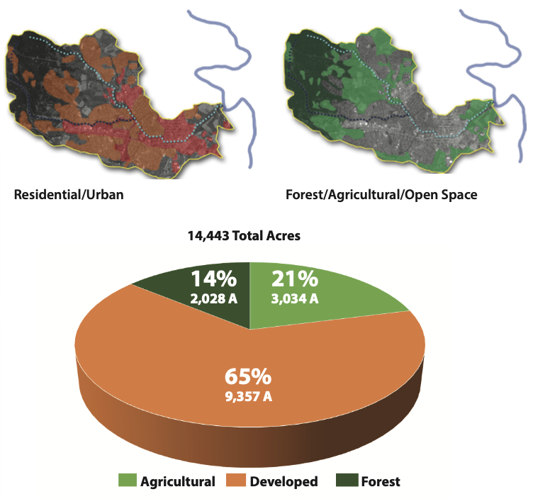
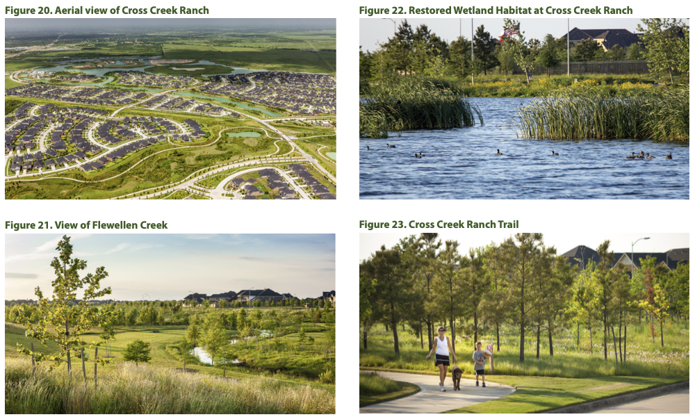
Cross Creek Ranch—A Greenway Precedent
An excellent example of a successful greenway project is the Cross Creek Ranch community on the fringes of Houston, Texas. The greenway is situated along the Flewellen Creek, a waterway that had been highly degraded by years of ditching by farmers and livestock grazing. The restoration of Flewellen Creek integrates the needs of people (waste water treatment, flood water management, and recreation needs) and the needs of wildlife (habitat re-creation) into one contiguous system.
Wetlands filter and treat waste water before it enters Flewellen Creek as well as provide valuable nesting sites for birds. The creek was transformed from a drainage ditch to a stream with greater ecological functionality. The addition of meanders and shaded cut banks slow and hold water during flash flood events, while also providing areas of protection for aquatic creatures.
The stream and floodplain were restored to a naturally functioning state and became the centerpiece of the 3200-acre Cross Creek Ranch development. The community is directly connected to this dynamic eco-system via a network of walking and biking trails.
Much like Houston and Cross Creek Ranch, The City of Frederick is a growing community. The City is located in a dynamic landscape of forested mountains and rich riverine valleys . As the population grows and the urban context of the City expands, it is essential to incorporate plans for preserving accessible open space, and for protecting ecosystem functions.
At its most basic, the design proposed here is an extension of the existing shared use corridor that transects the City. At its highest level of complexity, it is an ever-changing, immersive, and responsive merger of the urban environment and natural hydrologic systems. The conceptual design for the Carroll Creek Wildlife Recreation Area is a recreational space that incorporates the utility of a Shared Use Path with the beauty of ecological enrichment and the opportunities that come from connecting communities.
HABITATS
Habitats
At Highland Street, where the urbanized core of Frederick meets the rural fringe, Carroll Creek emerges from its underground channel into agricultural lands. This junction, where pavement gives way to soil and the creek is connected with its floodplain, marks the western boundary of what is here proposed as Carroll Creek Wildlife Recreation Area.
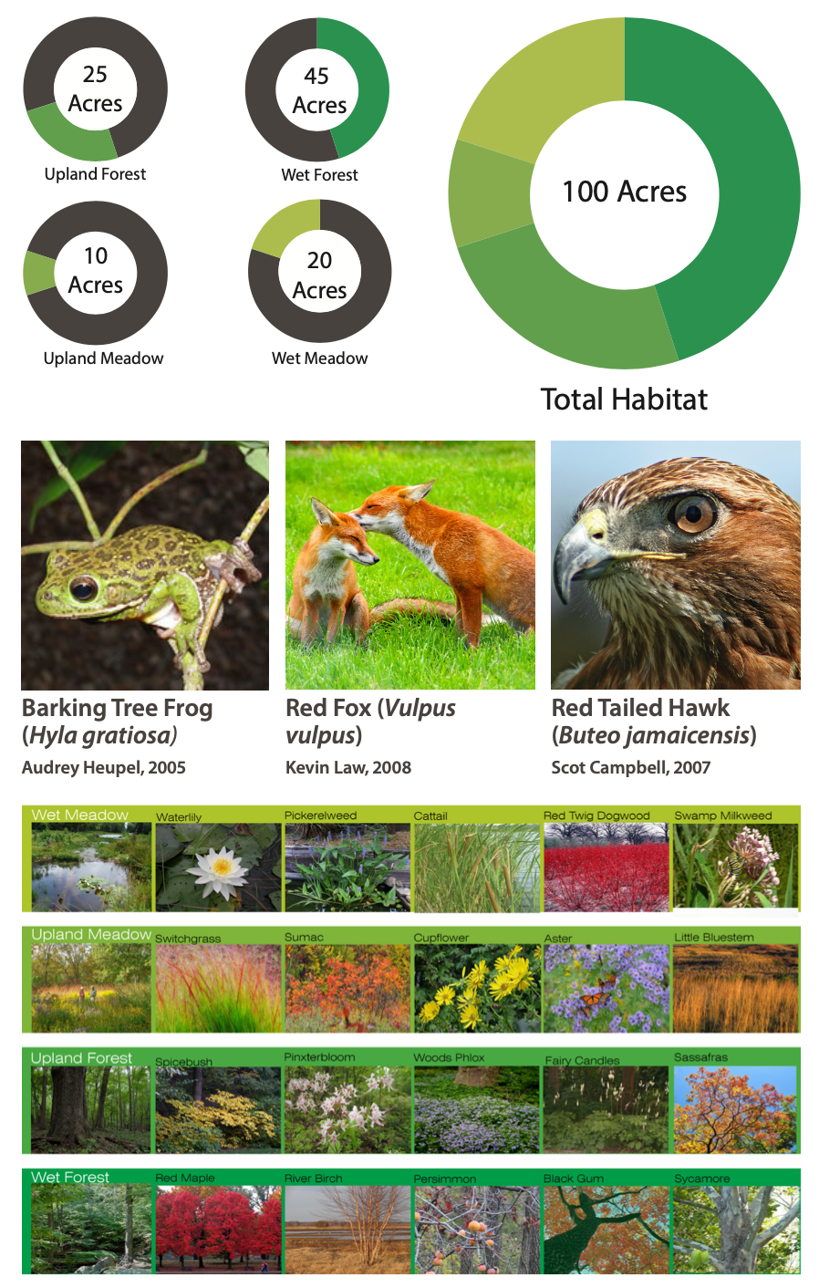
The existing topography and hydric soils of the floodplain suggest opportunities for at least four different habitat variations, which have been identified as wet forest, wet meadow, upland forest, and upland meadow.
“Wet” habitats are those correlated with areas of low slope and hydric soils, and will experience longer periods of soil saturation than “upland” areas correlated with steeper slopes or separation from the floodplain.
All organisms rely on multiple resources for survival, and cannot meet their needs in one type of habitat alone. Many species of butterfly, such as the Monarch, live as caterpillars in open meadows consuming herbaceous plants, but move to more sheltered areas to pupate. Birds of prey, such as owls, nest in forested environments, but hunt in open fields. By providing diverse and connected habitats types, Carroll Creek Wildlife Recreation Area provides more fully for native wildlife.


Characteristics of Habitat Types
WET MEADOW
The Carroll Creek Wildlife Recreation Area will preserve or restore approximately 20 acres of Wet Meadow. This habitat type, also known as Non-Tidal Shrub Wetlands, is characterized by plant communities such as water lily, pickerelweed, cattail, redtwig dogwood and swamp milkweed.
While much of Carroll Creek’s Wet Meadows have been cleared for pasture, hydric soils—soils suitable for wetlands to establish—still exist in the area; thus wetlands restoration is a key design feature. Restored wetlands will filter sediments and nutrients out of rain water flowing into Carroll Creek, and store and slowly release flood waters, helping to attenuate flooding in the area.
Wet Meadow wildlife habitat supports a wide diversity of species, including mammals like the Northern river otter and striped skunk; birds like the great blue heron, great egret, Northern waterthrush, American black duck and wood duck; reptiles like the Northern red-bellied turtle, spotted turtle, and eastern snapping turtle; and amphibians like the carpenter frog and New Jersey chorus frog.

WET FOREST
The Carroll Creek Wildlife Recreation Area will preserve or restore approximately 45 acres of Wet Forest. This habitat type, also known as Floodplain Forest, is characterized by tree species such as red maple, river birch, persimmon, black gum and sycamore, in addition to smaller trees, shrubs and herbaceous plant species. These plant communities will shade Carroll Creek to moderate its temperature, filter sediments and nutrients and stabilize the creek’s banks to improve water quality. The Wet Forests of Maryland provide a home to a great number and diversity of animal species, including mammals like the bobcat and red fox; birds like the bald eagle, black-throated blue warbler, pileated woodpecker and wild turkey; and reptiles like the bog turtle and northern red-bellied turtle.

UPLAND MEADOW
The Carroll Creek Wildlife Recreation Area will preserve or restore approximately 10 acres of Upland Meadow. This habitat type, also known as Grasslands, are upland treeless areas dominated by herbaceous vegetation, such as switchgrass, sumac, cupflower, aster, little bluestem and other grasses. While historically large expanses of Grasslands existed in many parts of Maryland, including in the Frederick Valley, these grassland eco- systems have since nearly vanished due to development, agriculture, fires and the disappearance of ungulates—large hooved mammals.
Upland Meadow restoration on the site will help mitigate stormwater from area roads, provide a key buffer for the restored wetlands, and help stabilize slopes. Upland Meadow habitat supports a wide diversity of species, including mammals like the long-tailed weasel, eastern cottontail woodchuck and least shrew; birds like the golden eagle, laughing gull, short-eared owl and rign-necked pheasant. By restoring habitat in this and the other habitat types, many animal species will find new homes and places to forage in Carroll Creek Wildlife Recreation Area, providing for a healthier ecosystem and exciting wildlife viewing opportunities for visitors.

UPLAND FOREST
The Carroll Creek Wildlife Recreation Area will preserve or restore approximately 25 acres of Upland Forest. This habitat type, also known as Mesic Deciduous Forest, is characterized by tree species such as tulip poplar, American beech, oaks, and hickories, with understories of spicebush, pinxterbloom, woods phlox, fairy candles and sassafras.
While Upland Forests are widespread throughout Maryland, many are overgrown by exotic invasive plant species like garlic mustard, Japanese stiltgrass, and other shade tolerant exotic weeds. Through upland reforestation and restoration, the exotic invasive plant species in Carroll Creek’s Upland Forest will be replaced by native plants to help restore the natural ecosystem that Maryland’s wildlife is best adapted to.
Maryland wildlife species typically found in Upland Forests include mammals like the gray fox, eastern spotted skunk, black bear, Virginia opossum, and long-tailed weasel; birds like the black-billed cuckoo, Kentucky warbler, least flycatcher, and red shouldered hawk; and amphibians like the barking treefrog and Eastern tiger salamander.


CONNECTIONS
Connections
The design of the Carroll Creek Wildlife Recreation Area revolves around connections; between past and present, city and country, downtown and East Frederick, people and nature, recreation and transportation, and between visitors and residents and the City of Frederick itself.
At present, the site exists an interstitial space between major thorough- fares, utilized within the context of the surrounding agricultural lands as additional grazing pasture . In the future, as the agricultural land is developed, the floodplain will come to be open space between two large residential developments.
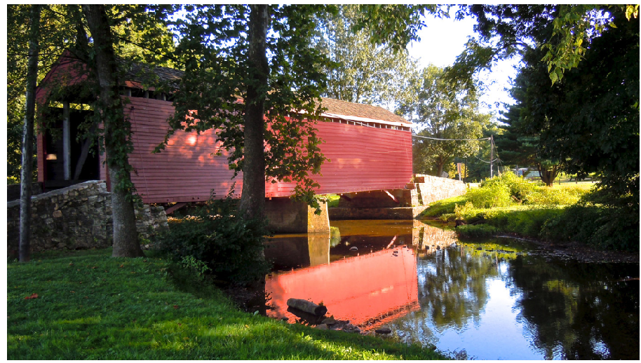
In initial visualizations of the alignment of the Shared Use Path, importance was placed on making connections between all thoroughfares and neighborhoods, as well as maintaining a connection to the site’s agricultural context and history by incorporating elements of the existing farm road and bridge into the design . Additionally envisioned was a spur connecting all these places to the forthcoming Monocacy River Trail.
The path is designed to minimize negative environmental impact without preventing users from experiencing the landscape. The primary trail skirts the periphery of the restored floodplain habitat to protect sensitive areas from excessive traffic. To allow users an opportunity to experience these areas more intimately, secondary pedestrian trails weave through forest and meadow areas. The forest trail follows a natural ridge above the flood- plain, and the meadow trail is a boardwalk meandering through the restored wetland habitat . This closer, quieter trail environment is meant to provide users with a special opportunity to connect with the natural environment.

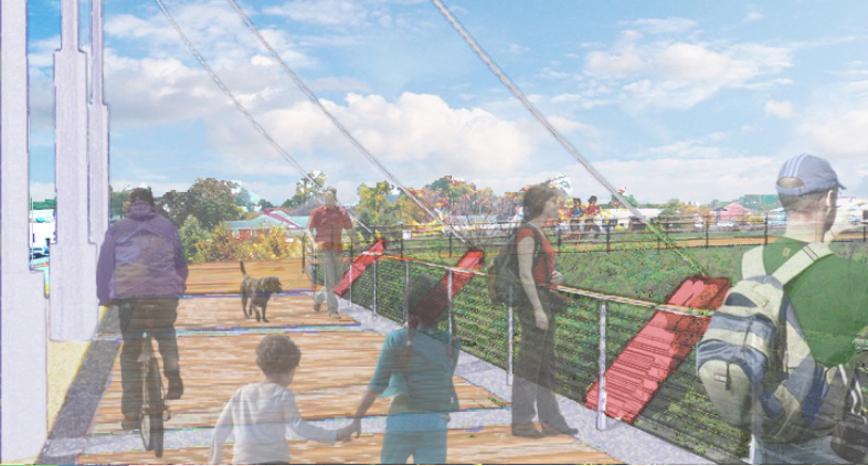
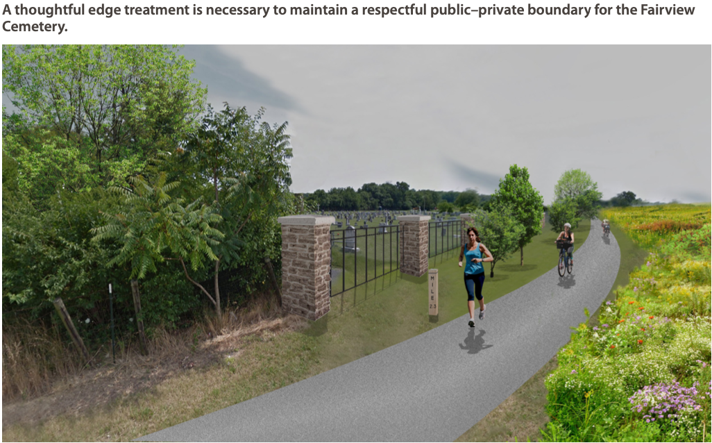
The Carroll Creek Wildlife Recreation Area would allow users a multitude of choices in terms of what paths to explore. Because of this, intersections offer wayfinding and interpretive information. Critical intersections have been identified as potential locations for waystations with amenities such as seating, playspaces, and restrooms . These primary connecting points would serve as landmarks as well as destinations along the path. The suspended path at the Highland Street bridge, for example, would act as a fulcrum between Carroll Creek Linear Park and Carroll Creek Wildlife Recreation Area, and denote entry into Frederick’s city center for those traveling from the Monocacy River Trail. Artful lighting and façade treatment would turn the existing culverts into a cultural amenity, and the visibility of this space from Highland Street would help to draw users to the recreation area. Just to the east of the Fairview Cemetary, a park-like waystation would provide a mid-trail access, interpretive information, and such amenities as parking, children’s playspaces, and panoramic views of the floodplain habitat and the diverse bridges crossing it. Other special connection points such as the covered bridge and the crossing between the two residential communities would add interest and orientation points for users.
The path would connect to the cross-city trail system and downtown, providing an efficient and enjoyable east–west transportation option for bicycle commuters.
The Carroll Creek Wildlife Recreation Area would become a city jewel, contributing positively to the identity of The City of Frederick, adding to community pride and increasing draw for visitors. The area would also give residents of the new developments along the creek a strong sense of place, and help them feel connected to the past and future of the water and the land.

HISTORY
History
The City of Frederick cherishes its history and the Carroll Creek Wildlife Recreation Area is an opportunity to bring more of this rich past to light.
The main path will run along Fairview Cemetery, site of an important burial ground. Fairview was established because other historic cemeteries had been neglected to the point of destruction, so were removed to this place. Information signs and a respectful border treatment will help show the respect the City holds for its forbearers.
Agriculture is and has always been a driver of the economy in central Maryland. Farmers and their families grew life and profits from the rich sediment deposited by frequent floods. Both sides of Carroll Creek were farmland—row crops and pasture—for 200 years or more. The option of retaining the farm road, which crosses from East Church Street to the Renn family farm, would give the old stories a place to roost . The bridge is to be clothed in a piece of cultural history, a covered bridge of the sort once common in the Maryland Piedmont. This will be in the Wet Meadow habitat, providing a perfect blind for bird watching. Signs explaining the restoration of Carroll Creek’s floodplain and the birds and other wildlife present will augment those unveiling East Frederic’s agricultural heritage.
SHARED USE PATH
The Shared Use Path
The Carroll Creek Wildlife Recreation Area Shared Use Path is designed to bring travelers close to Carroll Creek, heightening their experience of nature, yet keep them just far enough away to protect the habitat. The Shared Use Path alignment is illustrated in detail in the Appendix. For safety and ease of use, Frederick County Bikeway and Trail Design Standards have been met.
Trail alignment generally hugs the upper edge of the floodplain, avoid- ing most flood events. This will conserve the useful life of the pavement while taking advantage of commanding viewpoints. Spurs lead to different experiences; rest stops, informational signs, and benches will highlight these junctions.
The Shared Use Path offers varied scenery, a mix of sun and shade along an overall gentle ride with accessible adventures. Freedom, wide open views of forests and grassland, the silvery glint of water reflecting an ever changing sky—these are the lasting impressions walkers and bicyclists will take with them from the Carroll Creek Wildlife Recreation Area.
Bicycle and Pedestrian Trail Standards
A Shared Use Path is designed to accommodate a wide variety of users simultaneously. These users all have individual preferences for trail design, some of which may conflict with the needs and desires of other users. A successful Shared Use Path is one that balances these various needs and desires in order to serve as large a user population as possible while minimizing trail conflicts.
There are two distinct groups that use the Shared Use Path system: pedestrians and bicyclists. Pedestrians are characterized by their relatively slow speed of travel, and the desired trail surface varies: a hard paved surface is ideal for jogging or pushing a stroller, while a softer surface (e.g. crushed stone, or compacted soil) is easier on the joints. Bicyclists include both inexperienced cyclists who travel at slower speeds, and confident cyclists who want to go faster. Bicyclists' higher rate of speed necessitates a greater trail width to accommodate passing. Considering the design speed of the Shared Use Path is essential as it affects many design factors such as turning radius. The preferred surface for cyclists is a hard paved surface, such as asphalt or concrete. Finally, the trail must follow accessibility guidelines in order to accommodate users with disabilities.
In addition to minimizing trail conflicts between user groups, it is important to minimize conflicts between trail users and vehicles. As a rule, trail crossings over the road should be kept to a minimum, but if they must occur, then at-grade crossing should follow established standards. If the trail crosses a road that would be too dangerous for people to cross, then a below grade crossing should be considered.


Trails in the Floodplain
Shared use path trails are ideal for floodplain environments as they are capable of withstanding a flood event with minimal damage. Enhancements along the trail, including reforestation, creation or improvement of wetlands, and creation of riparian buffers, can make the floodplain more resilient to flood events. Trail placement should be sensitive to the floodplain and maintain a 50 foot buffer from the stream bank. Trails should avoid wetlands as much as possible. However, since wetlands are a unique educational opportunity, it is often desirable for people to explore them. This can be done with the creation of wetland boardwalks.


Trail Amenities
Bike Parking Bike parking will follow the guidelines outlined in the City of Frederick Bike Parking Design Guide
Signage Signage includes wayfinding signage and informational signage that highlights and explains the unique environmental, cultural and historical features of the site.
Rest areas In accordance to the Americans with Disabilities Act, rest areas are required every 1000 feet. These level areas adjacent to the main trial are outfitted with benches, allowing people to move out of the main flow of traffic to rest.


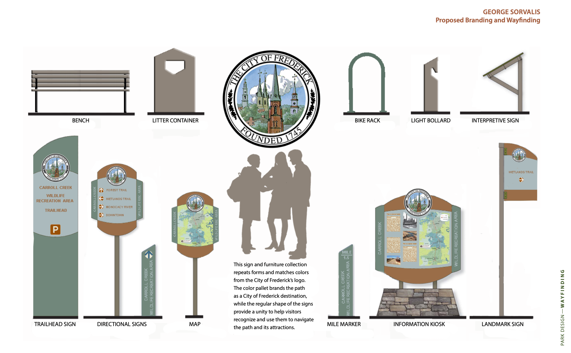
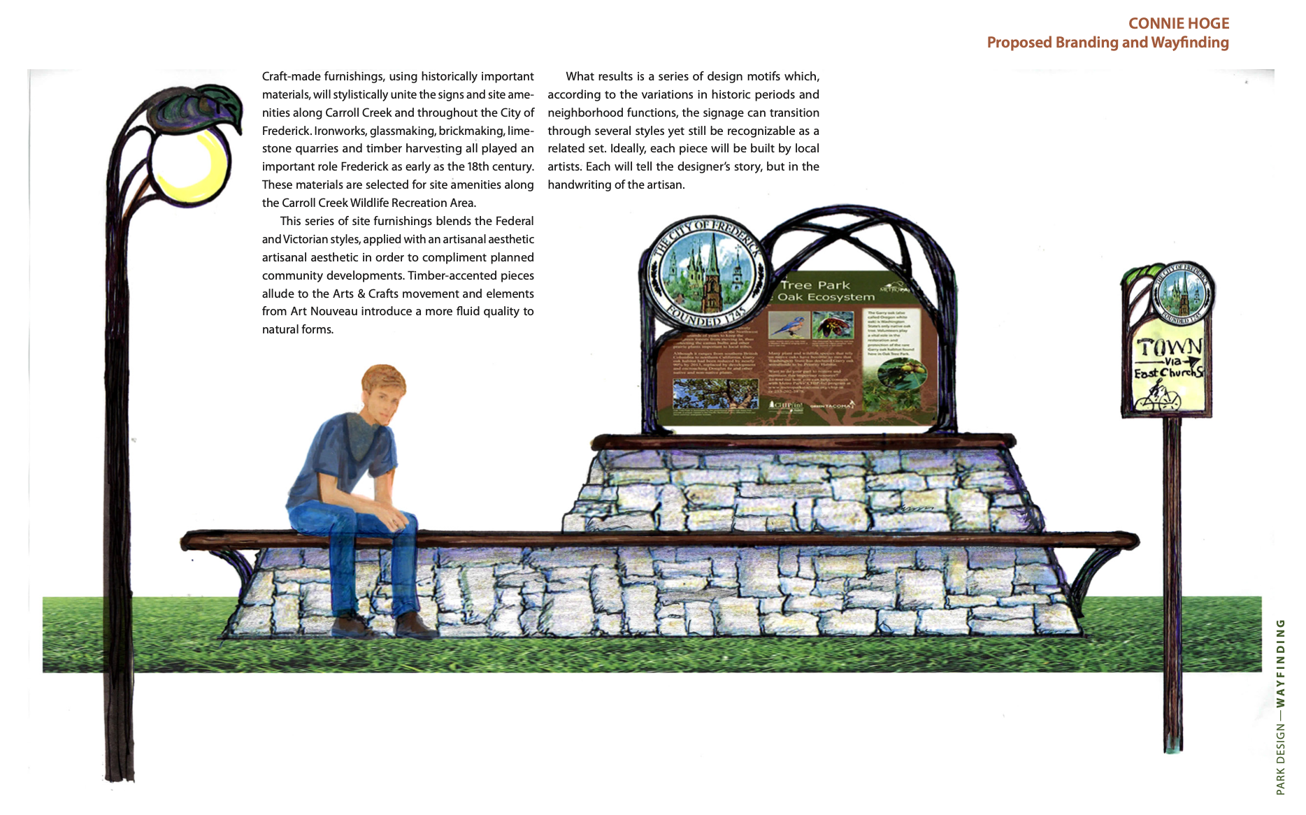
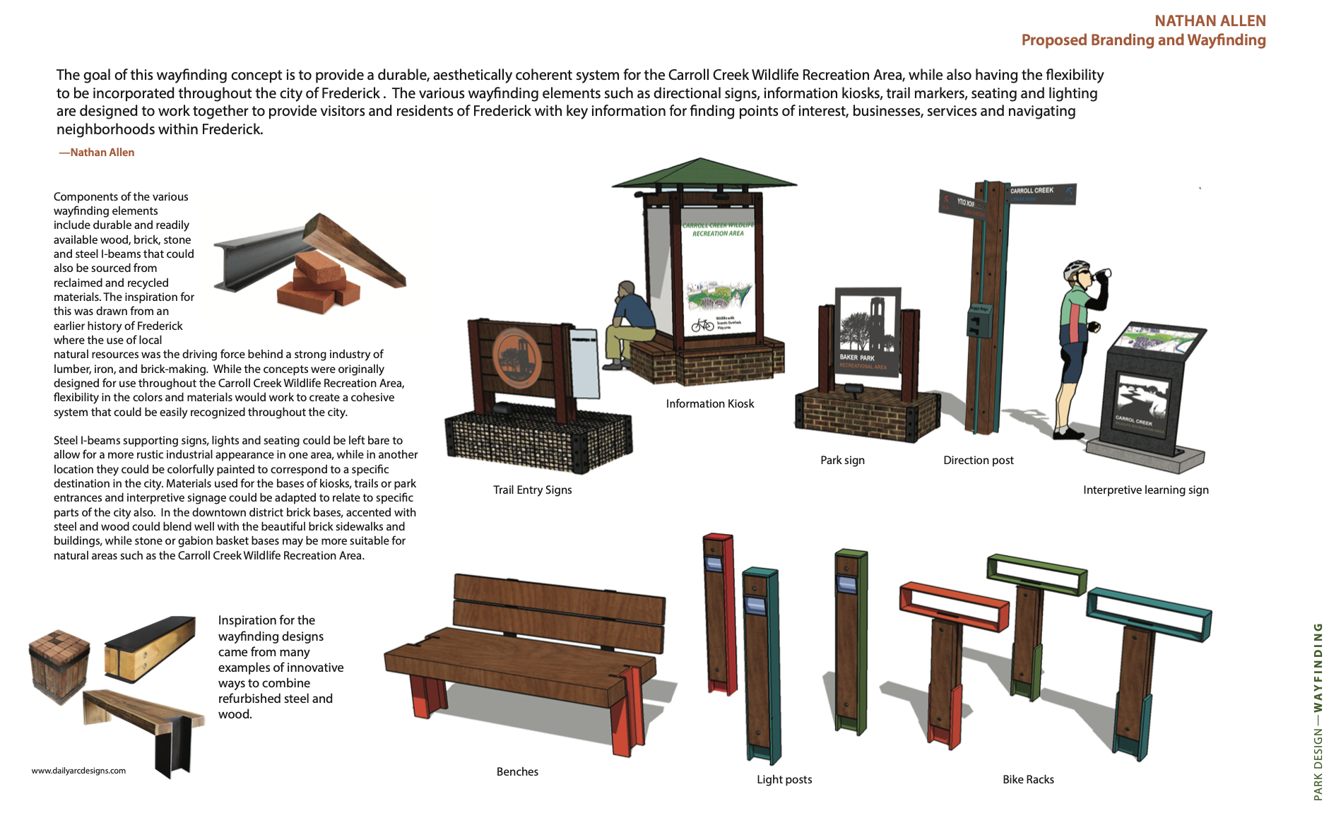
WAYFINDING
Wayfinding
The Carroll Creek Wildlife Recreation Area Shared Use Path will serve commuters, students, shoppers and nature-lovers. The path will connect East Frederick to Downtown, neighborhoods to each other, people to nature and the City to the Monocacy River. In this capacity it will attract hikers and bicyclists from out of town. Everyone will need directions and information in order to take in all that the Carroll Creek Wildlife Recreation Area has to offer.
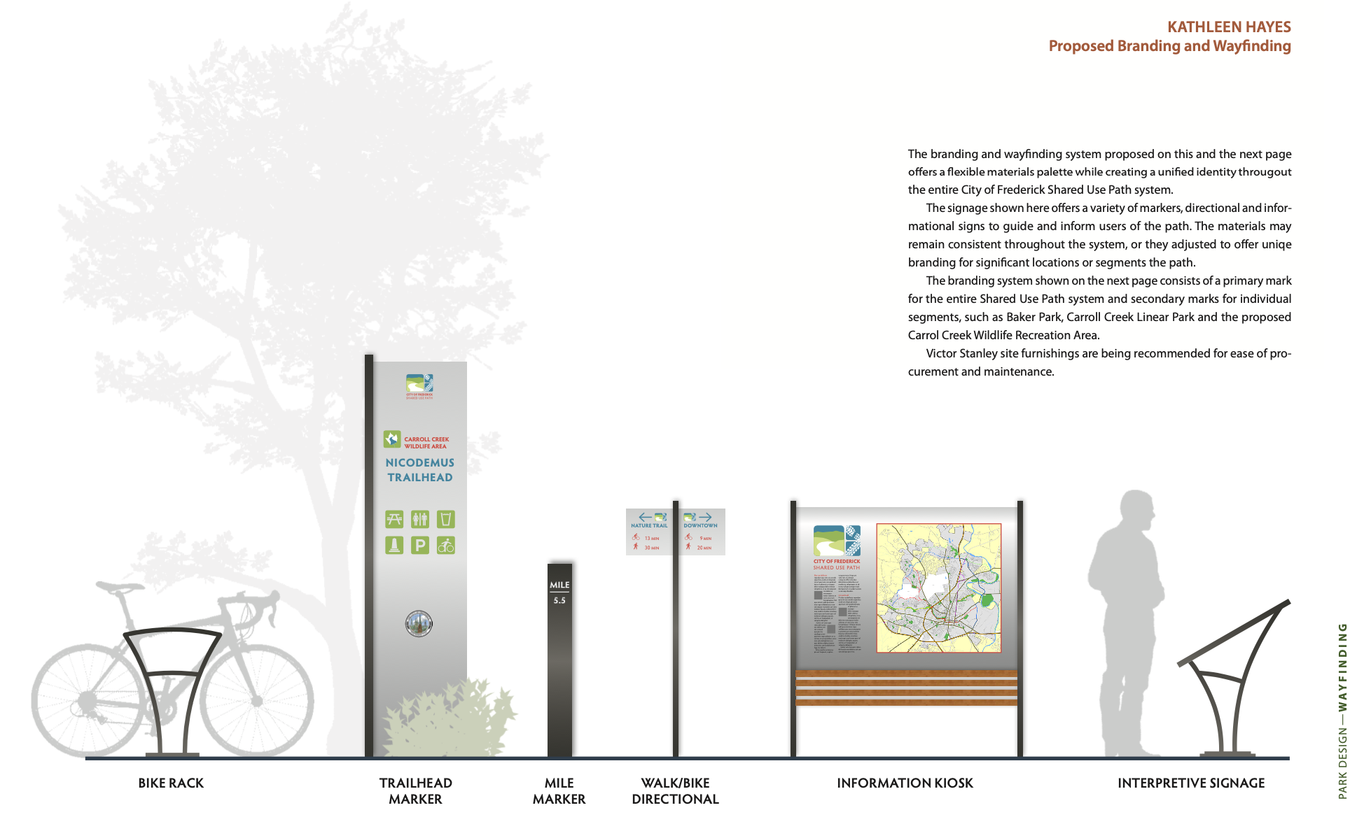
There are several methods of guiding visitors. Trail hierarchy is one. The 12-foot major path is striped with lane indicators and crosswalks. All secondary paths are narrower and the pavement is a different color blend. Junctions are clearly indicated by change in paving pattern, signs and furnishings. Trailhead signs will be illuminated and include brochures, maps, slope and distance information—highlighting points of interest along the various routes. Mile markers, path lights and streetlights keep travelers safe and oriented.
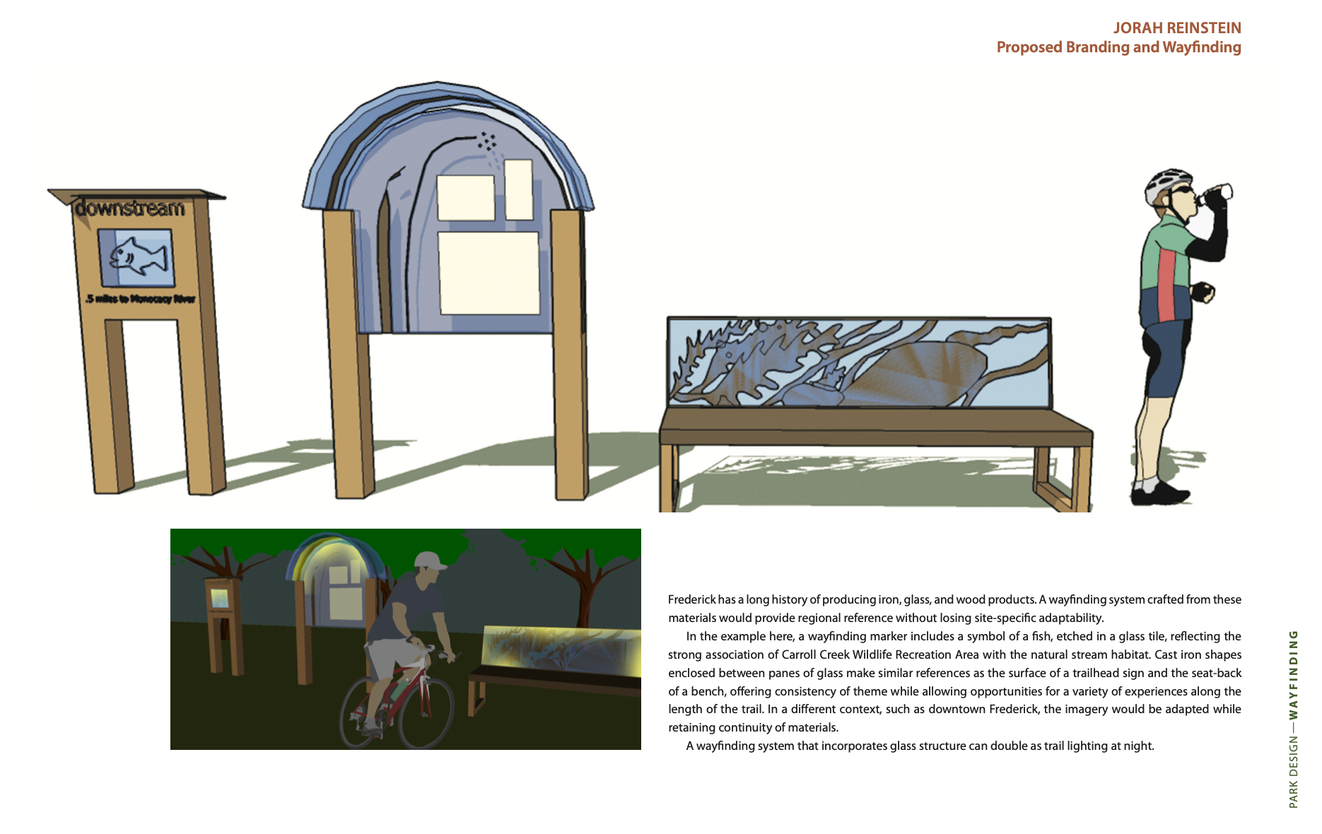
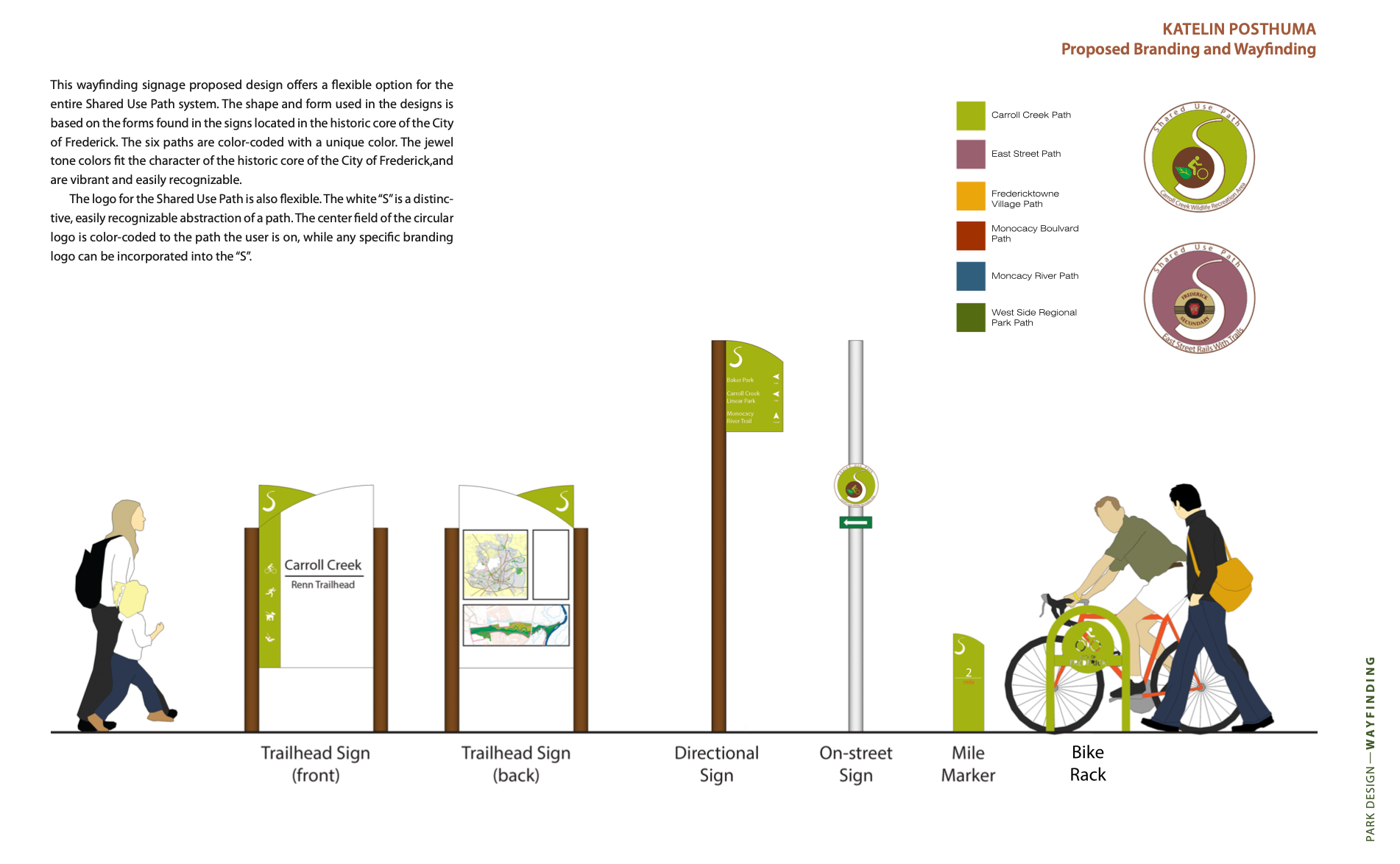
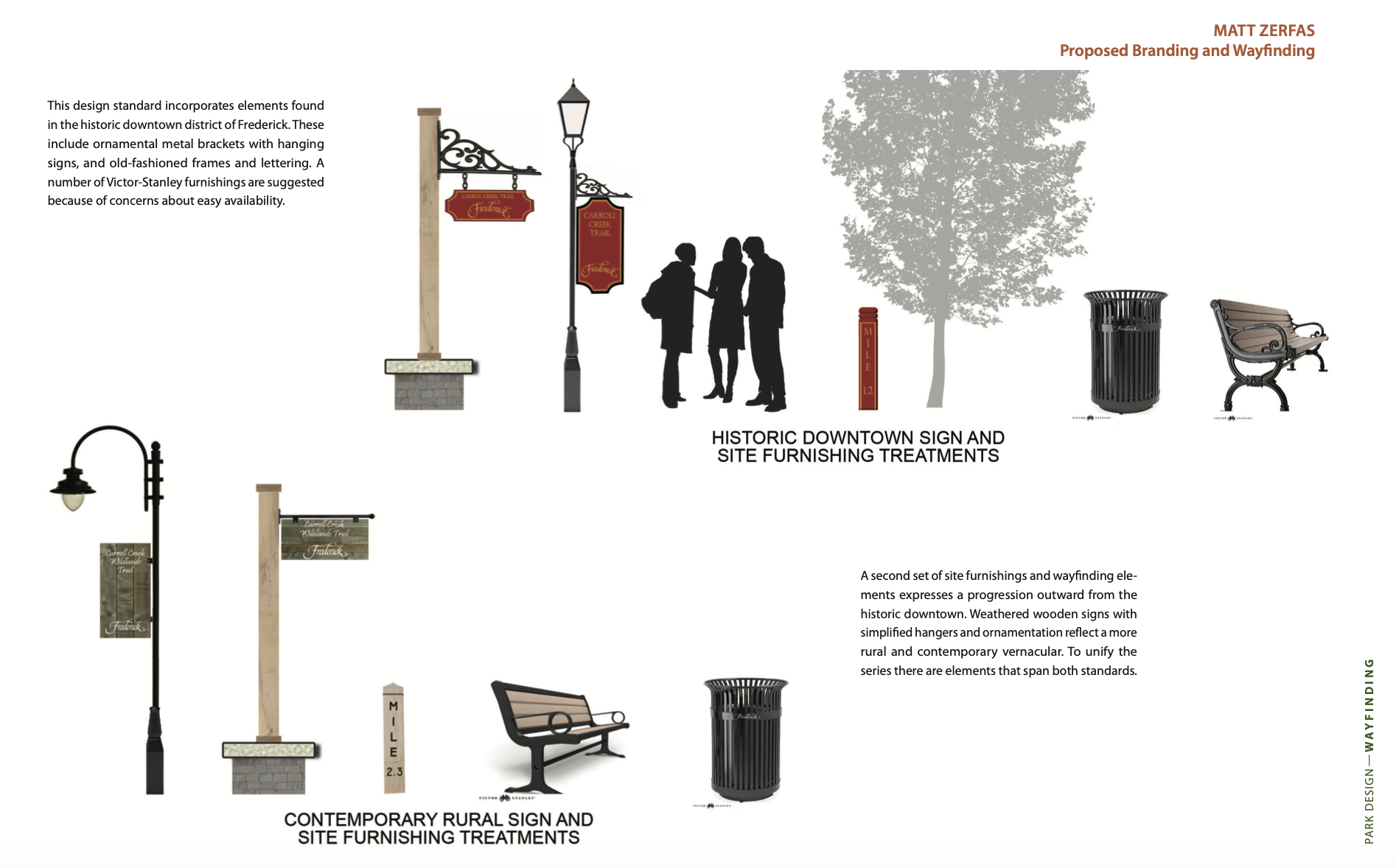
Many very fine artisans live and around of the City of Frederick. Their creative skills make the wayfinding and site furnishings distinctive. Artistically wrought signposts, bollards, markers and lighting gradually change in detailing as they progress from one area (natural, historic, entertainment, urban, residential, rural . . .) to the next. This artful blending portrays the character of the City of Frederick. The materials- glass, stone, wood and iron speak to us from Frederick’s rich history. There are also sturdy, well designed products available off-the-shelf from Maryland manufacturers that can fit in with the array of site furnishings.
Wayfinding Design Guidelines
“Wayfinding” refers to a system of signs, symbols, and landmarks that enable people to navigate through a space. A successful wayfinding system should be intuitive and simple, and yet still reflect the unique character and feel of the surrounding area. Successful wayfinding systems have 5 common features:
SIGN LOCATIONS
Sign locations should be focused on major points of arrival, departure, and transition. Circulation pathways should also be clearly delineated.
BRANDING
A clear, recognizable branding logo not only provides cohesion for the wayfinding system, but it also establishes the feel and character of the area around the signage - and therefore conditions people of what to expect while they’re using the space.

TYPOGRAPHY AND LAYOUT
Text is the primary means of delivering information to the viewer. Therefore, the typography should be consistent, legible, and clear. The chosen typeface should be appropriate (reflective of the character of the place), and communicative (suitable for what it will be communicating, and how it will appear).
COLOR
Color is a powerful design tool, with its own language and meaning. As a design tool, color often transcends
language barriers - everyone knows that green means go, and red means stop. Color should be chosen carefully, hues should match the site’s intended function and context . A successful wayfinding system is one that is legible at a glance, the foreground and background colors need to be intense and distinct enough to contrast each other, without being garish or distracting.

SYMBOLS & MAPS
Symbols and maps accentuate the information that is primarily displayed through text. Colors and symbols work together to allow the written information to be understood by people who don’t speak the language. While symbols are general, maps are specific. They allow people to orient themselves, show where things are located, and describe how the spaces fits into the larger context. A universally accepted pictogram system should be used, such as the symbols developed by the American Institute for Graphic Arts. Maps can be keyed with colors, or labeled directly.
MATERIALS
Materials and forms should be reflect the character of the place. Although the different types of signs will vary in shape, size, and information, a successful wayfinding system creates a “family” of signs that share a common graphic and formal language. These signs may be made out of a readily available material (such as aluminum). Changing the form and material type for certain signs provides a contrast between the “workhorse” signs, and the “special signs.” This provides a visual cue to the unique space surrounding this special sign. When practical and feasible, local materials, recycled mate- rials, and local fabricators should be used.

Student Work
PERFORMANCE
Landscape Performance
Landscape performance measures the,“effectiveness with which landscape solutions fulfill their intended purpose and contribute to sustainability.” Landscape performance can evaluated based on various metrics such as how a design creates or restores soil, improves water quality or flood protection, preserves cultural or scenic quality and impacts property values or operation and maintenance savings. Many landscape performance attributes have been designed into the proposed Carroll Creek Wildlife Recreation Area in terms of social benefits, wildlife benefits, flood protection benefits, and water quality benefits.
In terms of social benefits, the Carroll Creek Wildlife Recreation Area will provide a world-class recreation destination for The City of Frederick and for families who will reside in the hundreds of new homes slated for development adjacent to the site. 3 .4 miles of Shared Use Path and 1 mile of boardwalk and hiking trails will provide visitors with walking, jogging, cycling and intimate nature opportunities, while 3 way stations and 6 way points will educate users on design features and keep them oriented and on the right path.

Wildlife benefits will accrue from the approximately 100 acres of habitat the proposed design will create or preserve. The design will restore 45 acres of Wet Forest, 25 acres of Upland Forest, 20 acres of Wet Meadow, and 10 acres of Upland Meadow. Restored habitat will help recreate a healthy ecosystem that will draw more wildlife that kids love to interact with like butterflies, frogs and turtles; attract predators exciting to spot, like foxes and coyotes; and provide a home for birds of prey like hawks, owls, and bald eagles.
The vast majority of the proposed Carroll Creek Wildlife Recreation Area is situated in the 100-year floodplain - a low lying area subject to periodic flooding from large rain events in the immediate watershed, or extreme flooding when the Monocacy River is in flood stage and backs into Carroll Creek. Instead of attempting to resist flooding by elevating design features, and moving floodwaters elsewhere, the Shared Use Path and other features are designed to accept and accommodate floodwaters. This design performs in terms of flood protection benefits by retaining an open hydrologic connection with the Monocacy River, proving room for the Monocacy River to spread out over 45 acres of wet forest and 20 acres of wet meadow, attenuating flood heights up and down the Monocacy River.
The quality of the water flowing in Carroll Creek and being delivered into the Monocacy River and ultimately the Chesapeake Bay will be improved from wetlands restoration, and other benefits resulting from habitat creation and creek restoration on the site. Water flowing through a restored creek channel will contain less sediment, since it will be moving slower through the creek and through vegetated banks. This is in contrast to the current degraded creek that flows through exposed soil on banks void of vegetation that erode into the creek with every large rainfall. Reforestation and native plantings will also do a better job filtering pollution picked up by storm water after rains, keeping the water in the creek cleaner. Cleaner water will help the creek ecosystem support more fish and wildlife and foster better sights, sounds and smells for users.
The many multi-faceted benefits of Landscape Performance are being designed into the proposed Carroll Creek Wildlife Recreation Area to provide users a world-class recreation destination that is environmentally, economically and socially sound.