ARLINGTON ECHO
Arlington Echo is The Environmental Literacy and Outdoor Education Office of Anne Arundel County Public Schools (AACPS). The 24-acer site located on the Severn River was purchased in 1971 from Arlington Presbyterian Church of Baltimore. It was then transformed from a youth camp into the Outdoor Education Center it is today. The site is dedicated to “Empowering students of all ages through authentic hands-on outdoor experiences with the environmental knowledge, skills, and motivation to make and act upon responsible environmental decisions.” Through programs that are developed on site, Arlington Echo is able to provide face-to-face instruction to more than 25,000 students and 8,000 adults each school year. Since they are part of the curriculum and instruction of Anne Arundel County Public Schools, they are able to reach students at all grade levels.
Arlington Echo states that their goals are to:
Develop and implement a prekindergarten through high school environmental literacy curriculum and program that align the MSDE Environmental Literacy standards with up-to-date standards in other core content areas.
Empower teachers to use the environment and outdoors as a context for learning
Support the AACPS Strategic Plan of Community Involvement and Chesapeake Bay Watershed Agreement by serving as a community resource for educating and building stewardship among the citizens of Anne Arundel County.
PROJECT SUMMARY
Arlington Echo is an outdoor education facility serving all primary and secondary public schools in Anne Arundel County. The facility is aging with one key building in need of replacement due to earthquake damage. It’s location along the Severn River makes it a popular place for county agencies to book meetings and retreats leading to a major parking deficit onsite. In addition, the campus was not originally designed to accommodate wheelchair accessibility and needs to be fitted with trails and accommodations that enable physically challenged children to participate in the environmental learning activities offered at Arlington Echo.
Anne Arundel County has partnered with the Smart Growth Center PALS program to provide the design opportunity to the University of Maryland Landscape Architecture Studio of Spring 2017. The design process began with research on site design standards and analysis of the abiotic, biotic and cultural systems.The extensive analysis enabled a comprehensive understanding of what is on and around the site, as well as the issues that must be address through innovative design practices. A set of specific goals and objectives were developed to help guide design decision making.
Goals:
- make all important site facilities accessible by wheelchair
- enhance the visual quality of the center along an environ- mental sustainability theme
- improve the outdoor teaching and activity spaces on site
- strengthen the resiliency of the center to accommodate the high student traffic
- maintain the goal to be a demonstration center for sustainability practices
- maintain and enhance the native biodiversity
Objectives:
- improve accessibility to the wetland walk
- reorganize the gathering spaces outside the dining facility
- develop a strategy to accommodate parking that protects people and the environment
- review current standards and opportunities for the challenge courses
- review/revise the existing trail circulation system
- enhance the function and visual quality of the arrival/ drop off area
- identify opportunities for habitat creation/preservation
- develop a plan for a nature play space
- develop a stormwater master plan for improved water quality treatment (with a learning component)
Challenges:
- expansion of parking facilities
- creation of an accessible trail system to handicap
- re-envisioning of campus activity spaces
- improvement of visual quality and environmentally sustainable aesthetic
- maintenance and enhanced resiliency of the site biodiversity
Four design teams were established leading to four unique master plans for the Arlington Echo property. It is hoped that these designs will provide a foundation upon which a comprehensive upgrade for the outdoor education center can be built.
HABITATS
Forest Habitat
The Atlantic White Cedar Restoration project seeks to restore the tree population because they are globally threatened. The east side of Arlington Echo’s site is bordered by the Indian Creek Branch Cove. The soil conditions and hydrology in the cove are suitable for growing Atlantic White Cedars. Arlington Echo received fund- ing to propogate the trees because they help improve the health of the Chesapeake Bay. Currently there are 40 seedlings, 88 living trees, and 25 dead trees.
Maintaining Forest
The goal is to maintain the natural feel of the site through minimal design disruption. There is a need to develop, expand,and preserve the site to rejuvenate its efficiency. Saving as many trees as possible through low impact development design will help preserve existing wildlife habitat. Designing within the exisitng forest and canopy cover will promote a cohesive space throughout the site.
Existing Trees
Some of the most prominent trees on the site are Inkberry (Ilex glabra), Red Oak (Quercus Rubra), Loblolly Pine (Pinus taeda), American Holly (Ilex opaca), Spanish Oak (Quercus falcata), and Chestnut Oak (Quercus montana).
Meadow Habitat
A meadow habitat is an ecosystem composed of one or more plant communities dominated by herbaceous species; woody vegetation may also be present but is not a dominate characteristic. Meadows serve many functions between serving as a stormwater filter to an area that supports breeding grounds for many different species of animals and insects while also serving as a key source of food for many different species of bird. Meadows can be either dry or wet so when locating a proper meadow habitat it is more important that the site receives a minimum of direct sunlight for 6 hours a day.
Native Plant Selection
- Butterfly Weed- (Asclepias tuberosa)
- Black Eyed Susan- (Rudbeckia hirta)
- Big bluestem (Andropogon gerardii)
- Evening primrose (Oenothera biennis)
- White turtlehead (Chelone glabra)
- Purple coneflower (Echinacea purpurea)
- Rough goldenrod (Solidago rugosa)
- Switchgrass (Panicum virgatum)
- Cardinal flower (Lobelia cardinalis)
Aquatic Habitat
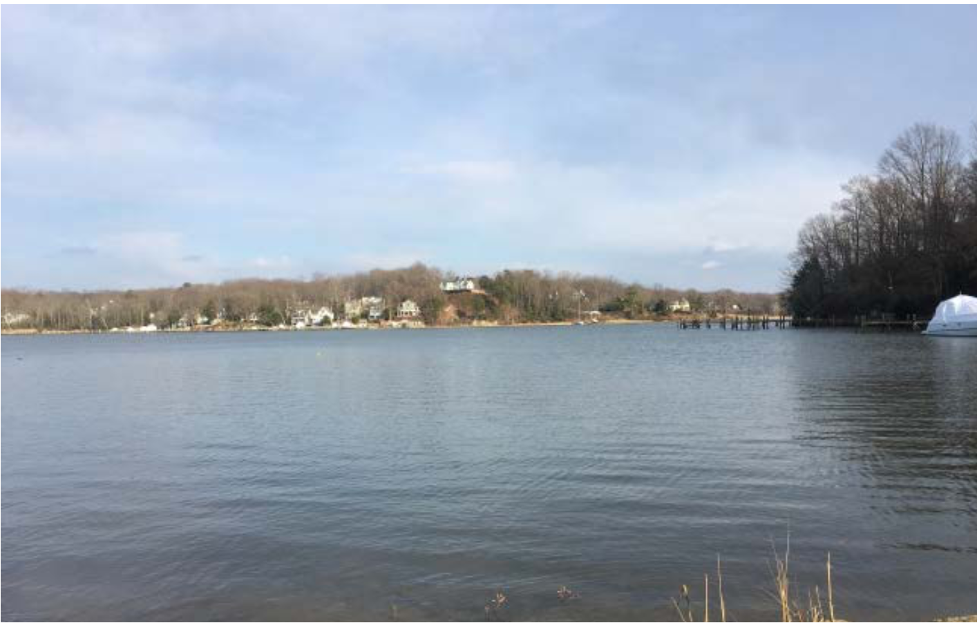
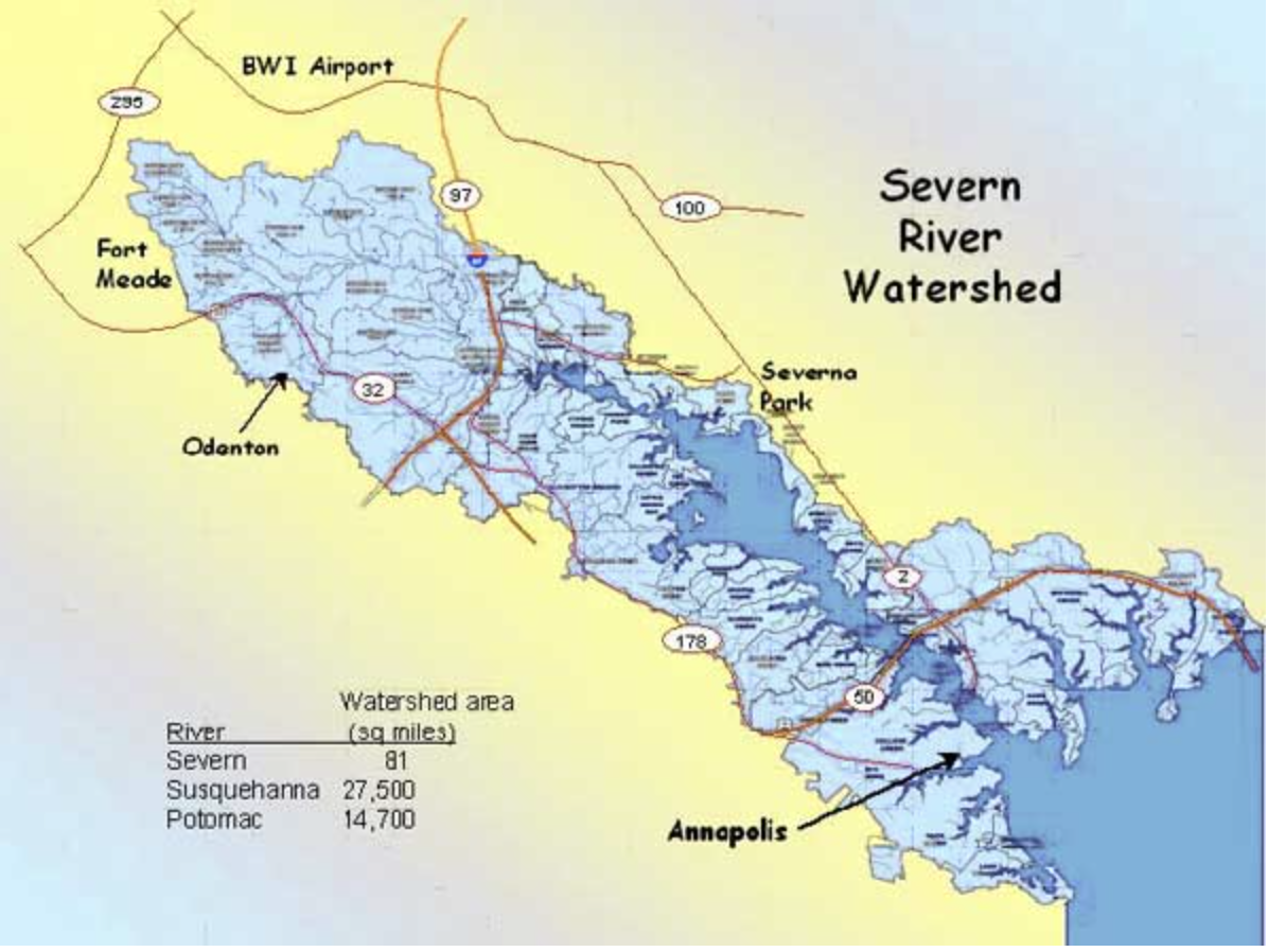
Arlington Echo’s aquatic habitat is located along the Severn River within Anne Arundel County. The Severn River watershed is approximately 43,000 acres and has 40 smaller tributaries. The tributary located on Arlington Echo’s site is known as the Indian Creek Branch. The salinity is dominated by the adjacent Chesapeake which is a balance between fresh water coming down the Bay from the Susquehanna River and denser salty water moving up the Bay near the south. During the spring and the fall maximum averages 11-12 parts per thousand while during the summer there is a low salinity. This means that many marine fish species that frequent saltier lower Chesapeake will not be found here. This also makes the Severn River a good place for oyster restoration because organisms that cause oyster disease do not flourish at these low salinities.
Within the Severn river, there are many types of species that benefit from the habitat that the watershed provides. Among these species are the American Eel, Blue Catfish Blue- gill, Brook Trout, Brown Bullhead, Channel Catfish, Common Carp, Flathead Catfish. Approximately 350 species of fish live in the Chesapeake Bay. Some fish are in the area all year-round round, while others swim into the Bay from the ocean to feed, reproduce or find shelter. Other species that live in this habitat are Great blue heron, Louisiana water-thrush and the yellow-crowned night-heron.
The Severn’s water quality is measured through a monitoring program where 15 sampling stations are monitored every 1-2 weeks. Through these studies, it has been discovered that dissolved oxygen is a major problem affecting the water. There are multiple “dead zones” located throughout the Severn River, which are areas where the oxygen levels are below 0.2mg/liter.
SITE CONDITIONS
Soils
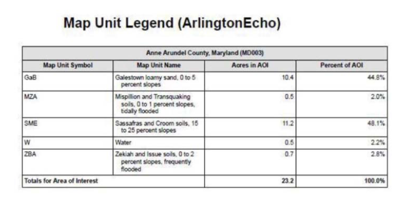
Arlington Echo consists of four major soil groups. They are MZA, GaB, ZBA, and SME. Each of the soils listed has unique qualities that make them suitable for different applications. The USDA web soil survey data has produced a soils report that gives the specific uses for all soils on the site.
Galestown Loamy Sand
- Somewhat limited for paths and trails
- Hydrologic rating A
Mispillion and Transquaking Soils
- Very limited for paths and trails Hydrologic rating A/D
- High seedling mortality rate
Sassafras and Tranquaking
- Somewhat limited for paths and trails Hydrologic rating C
- Steep slopes
Zekiah and Issue
- Very limited for paths and trails • Has a .37 K factor for Erosion
- Frequently flooded
- Hydrologic rating B/D
- High seedling mortality rate
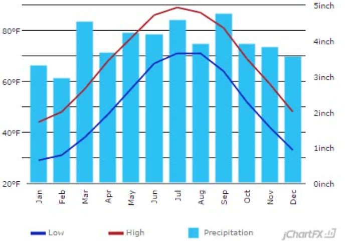
Climate
Arlington Echo has a fairly mild climate. The average annual temperature is 59°F, with a high of 67.8 °F and a low of 50.2 °F. The site receives a fair amount of precipitation, with an annual average of 47.32” of rain and 9” of snow.
Depending on the time of the year, the amount of daylight that the site receives rages from 9 to 14 hours. Humidity also varies with the seasons, often reaching up to 90 percent during the summer months. Natural disasters are somewhat uncommon. Very few hurricanes directly hit Maryland, although the effects from some can still be felt.
The majority of the site is wooded so direct sunlight is reduced, often helping to reduce heat during summer days. The wooded conditions also help with reducing wind. Due to the sites changing topology, the orientation of the site is varied, with many of the slopes facing the sun between southeast and southwest.

TEAM 1
Clean the Water, Recover the Shores, Honor the Heritage.
Mission
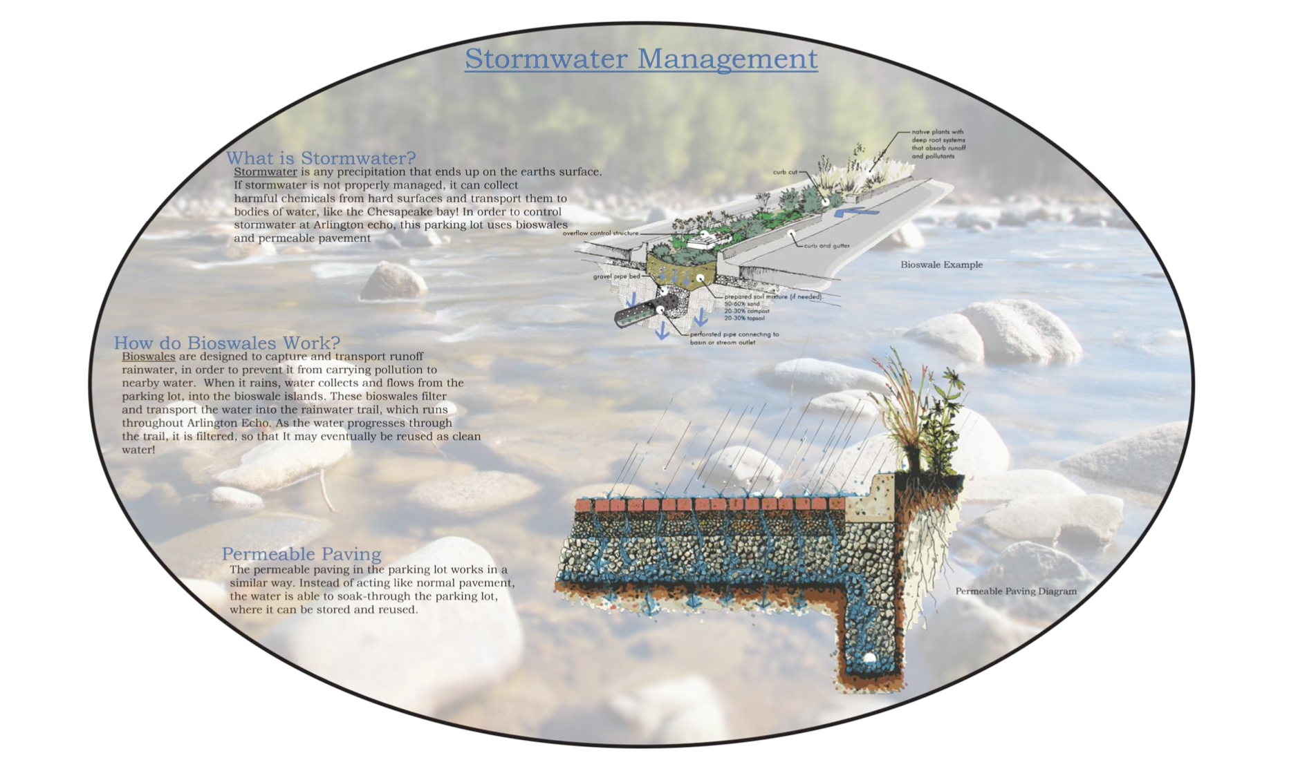
As an outdoor learning center, Arlington Echo Park is designed to provide various activity spaces for children with trails and nature playgrounds that are ADA accessible, The design also attempts to be age inclusive with sites such as the enhanced marsh boardwalk, the living shoreline. The existing parking is being renovated with permeable pavings, biorention buffers, and increased parking spaces.
The entrance incorporates rainwater features that can also serve as entrance guides, interactive equipment, and lights throughout the site to reinforce the journey of stormwater for visiting students.
The rest of the site design incorporates stormwater design elements that can be utilized for teaching purposes. Stormwater management features can be aesthetically pleasing, environmentally conscious, and functional for outdoor teaching exercises.
 |
 |
 |
 |
Objectives
- Provide stormwater management system throughout campus to narrate the journey of run-off to visiting students.
- Improve open areas, marsh, and living shoreline for more outdoor teaching opportunities.
- Expand parking lot to relieve parking and bus arrivals.
- Provide accessible trail systems for all people to enjoy their time at Arlington Echo.
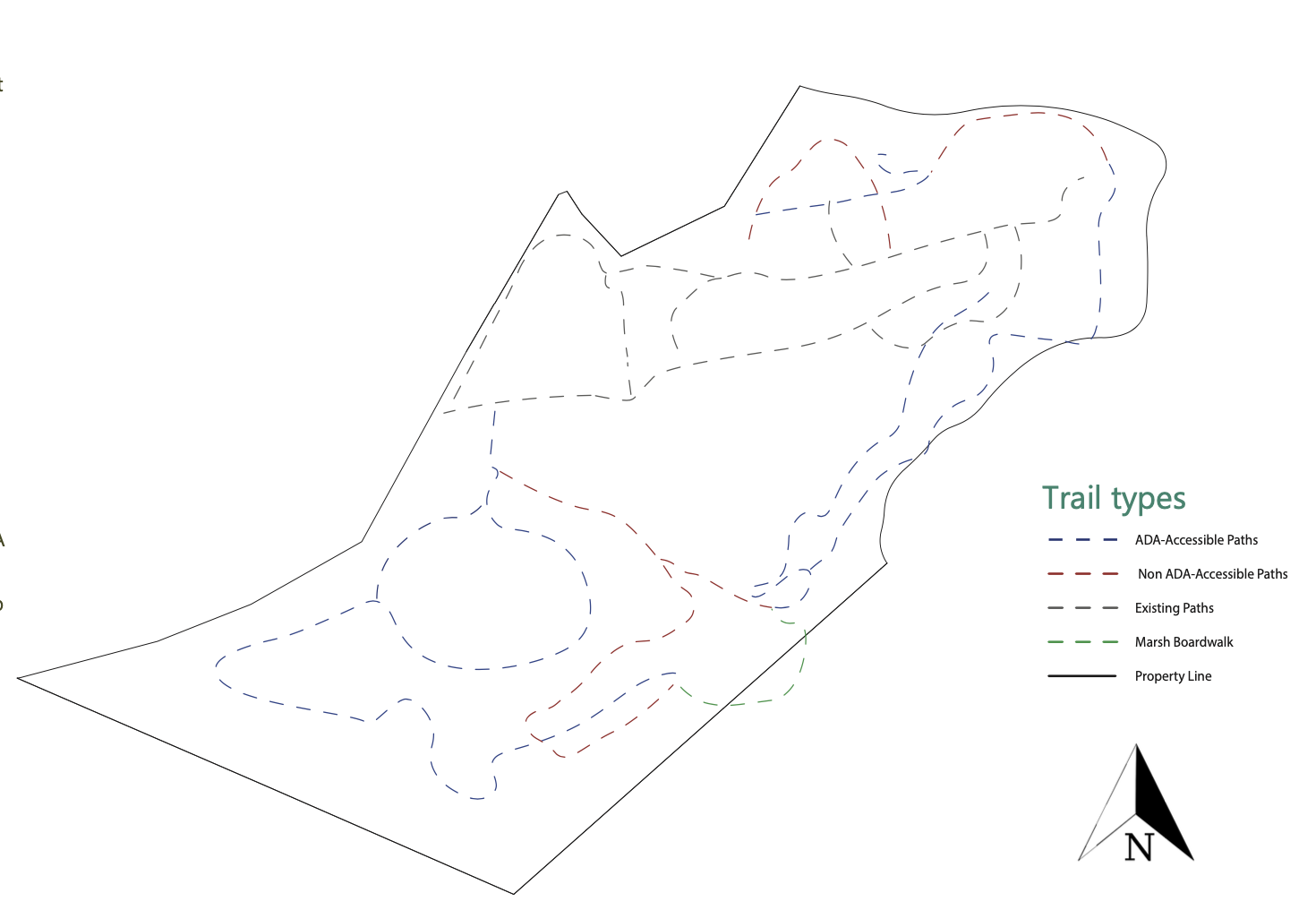
Trail Circulation
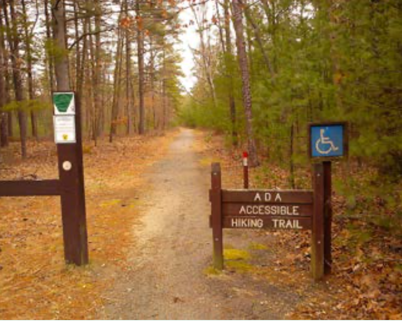
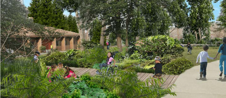
The campus trail system and overall circulation has also been redesigned to better support ADA accessibility. The current trails often feature very steep sections that would be difficult to traverse by wheelchairs, which prevent certain users from enjoying Arlington Echo’s natural environment. The current
trails have been kept where they are, but new, entirely ADA accessible trails have also been created. These trails range from 5 to 8 percent slope, with the majority being 5 percent for ease of use. These will allow those in wheelchairs to comfortably and confidently explore Arlington Echo.
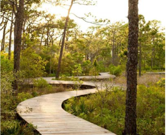
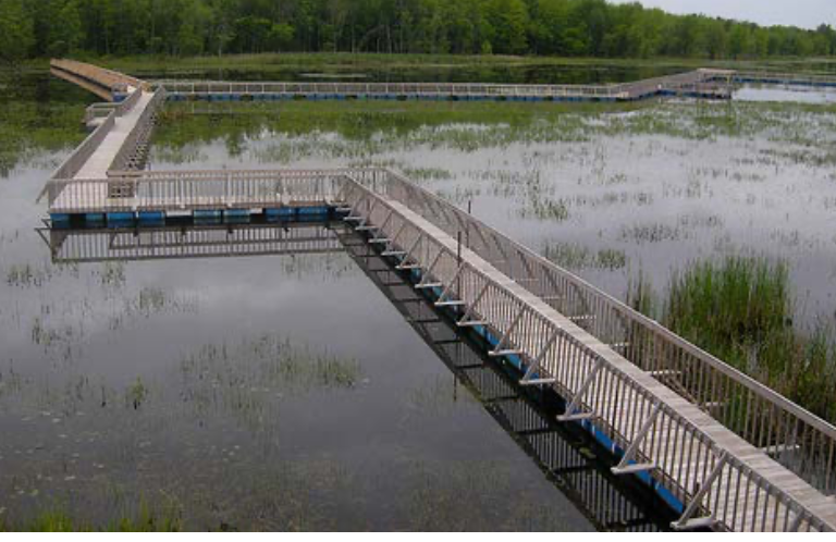
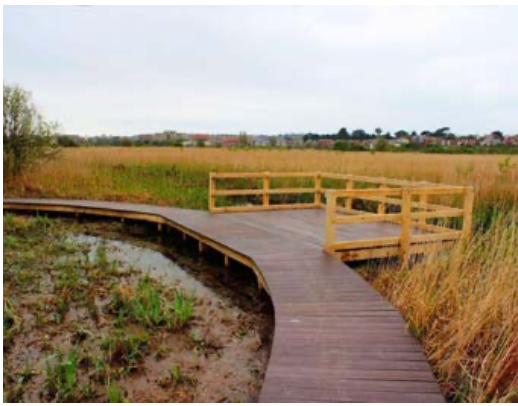
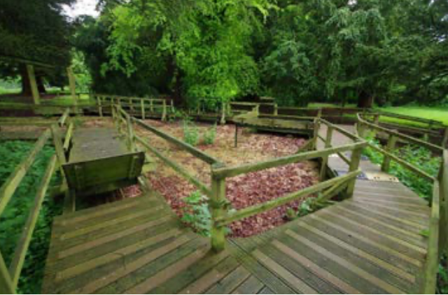
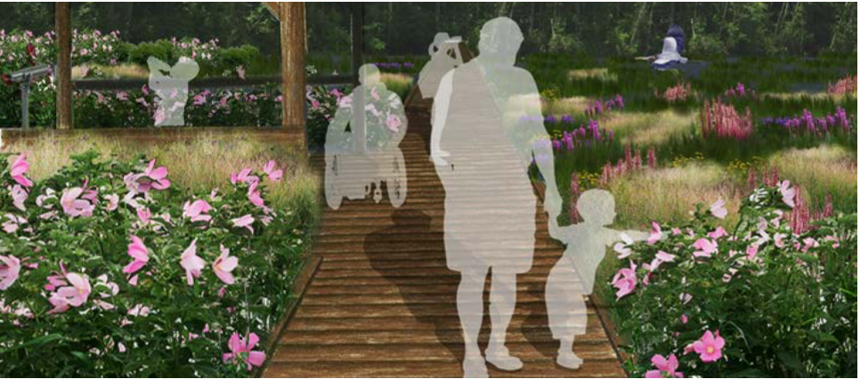
These trails run from the start of the challenge course, down to the marsh boardwalk, and around the living shoreline, eventually connecting with the northern amphitheater. The boardwalk itself has also been modified to allow for wheelchair access. The new boardwalk features a more curvilinear and natural shape, and is completely flat across the whole distance. A handrail has also been added to ensure safety. These new paths allow for full access across the campus for anyone who wishes to use it.
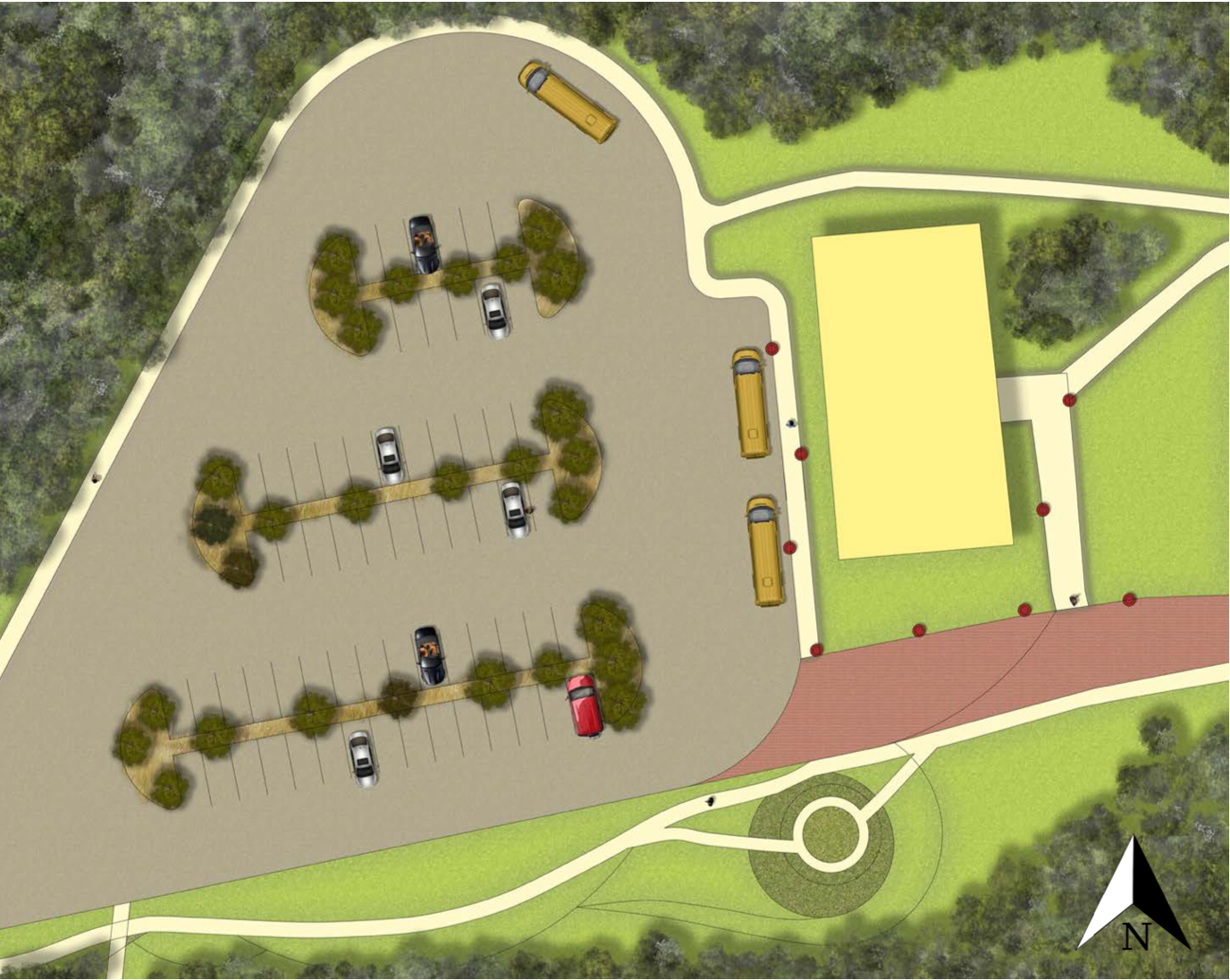
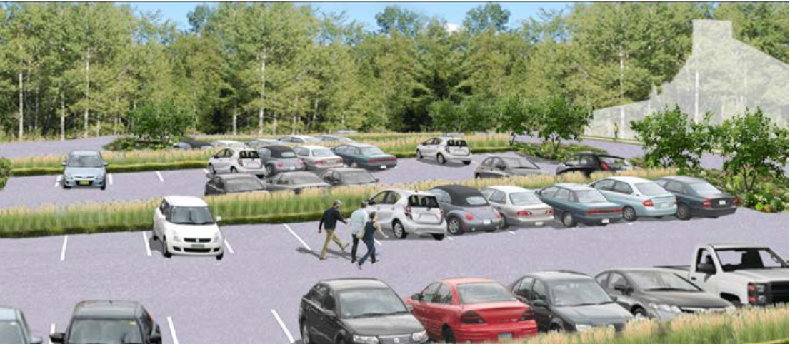
Parking
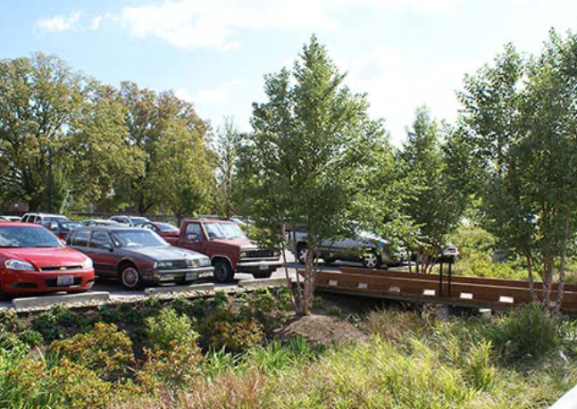
One of the major proposed changes to Arlington Echo is the expansion of the current parking area. The current parking situation includes around 40 spaces which are spread throughout the campus. The lack of centralized parking often forces cars to find non conventional areas to park during crowded days. The redesigned parking lot solves this problem by providing 64 total spaces located by the entrance to Arlington Echo.
The parking lot features 10,368 square feet of permeable paving, designed to collect and filter water that would otherwise end up as polluted runoff. In conjunction with the permeable paving are bioswale medians, which are designed to capture and transport rainwater to a nearby educational rainwater trail that runs through the campus. All of the water that flows into this parking lot will be filtered for reuse as clean water. The outer edge parking lot will
be enclosed by a green wall, in order to screen the campus from the external properties and to preserve the natural aesthetics of Arlington Echo. A new truck turnaround has also been added by the diner, to provide ease for any deliveries that need to be made.
Stormwater Management
Performance Metrics
Parking Lot will produce 77,418 gallons of runoff during a storm event producing an average of 2.7” of rain. The average for this site is about 1.7” permeable pavers in parking lot can store up to 61,635 gallons of water which is more than enough for the site’s average of about 1.7 inches of rain
TEAM 2
Problems cannot be solved at the same level of awareness that created them.
Mission
Create an outdoor education campus that brings students of all ages and abilities closer to nature through on-hands learning and makes lasting impressions.
Objectives
- Improve ADA accessibility on site for pedestrians
- Increase the number of parking spaces while using LID techniques
- Increase on-site learning through memorable experiences
- Create new views
To achieve these design goals, new trails and a parking spaces have been added, as well as new, unique spaces for visitors to experience and learn about nature.
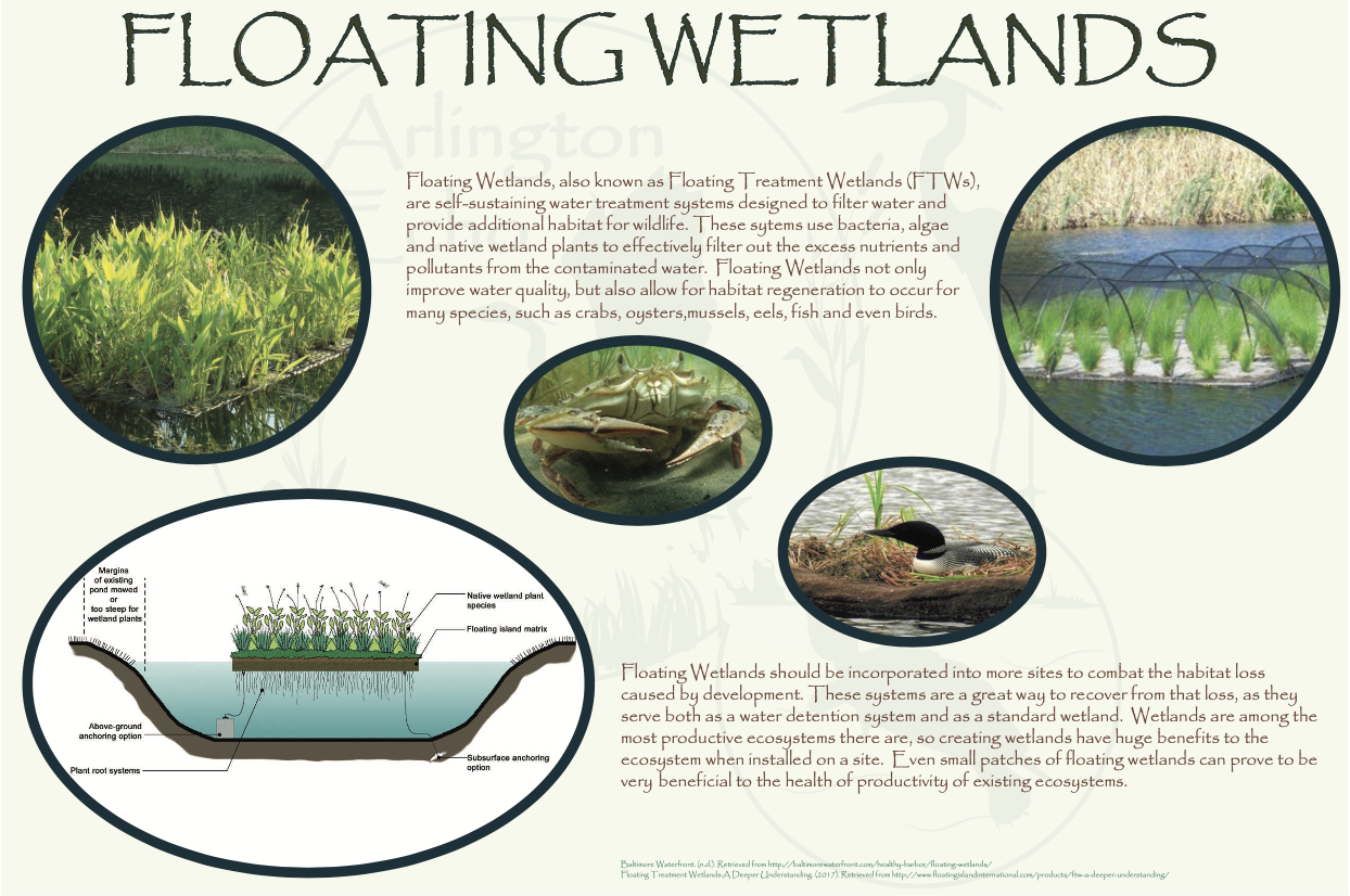
To achieve the third design goal, floating wetlands proposed are installed near the boating docks. Floating wetlands are a versatile educational tool, as they not only create additional habitat to study wildlife, but they also filter and clean the water. These will need to be replaced every few years. The replacement process provides another hands-on learning opportunity in getting students to learn about recycling materials, and how to make floating wetlands out of recycled materials.
 |
 |
 |
 |
Circulation
It is important that the visitors at Arlington Echo are able to safely and easily move around the campus. In the current conditions many of the trails are too steep and dangerous for anyone with a disability to maneuevor, preventing them from reaching the water’s edge. There is also the issue of food delivery trucks backing up a long stretch of road in the middle of campus, which is a safety concern with children running around. To combat this problem, there is going to be a turn around pad installed next to the Resource Building.
A major focus of this design was to bring as many people
as possible to the water’s edge on the south side of the campus. The habitat located along the creek provides a unique education- al opportunity to learn about marshes, and marsh wildlife that is otherwise not accessible to many Prince George’s County students. To achieve this goal, new trails are created with a gentler slope, and compacted tread material to allow everyone, regardless of ability, to travel freely throughout the campus. There is also a new trail connecting the existing boardwalks; from the boating docks to the marsh boardwalk.
The other major goal was to remove the presence of vehicles from around the site, and condense them into an efficient, low impact parking lot. The parking lot utilizes techniques, such as vegetated islands and bioswales, to add vegetation back to the site as well as manage stormwater runoff.
Floating Wetlands
Floating Wetlands, also known as Floating Treatment Wetlands (FTWs), are self-sustaining water treatment systems designed to filter water and provide additional habitat for wildlife. These systems use bacteria, algae, and native wetland plants to effectively filter out the excess nutrients and pollutants from the contaminated water. Floating Wetlands not only improve water quality, but also allow for habitat regeneration to occur for many species, such as crabs, oysters, mussels, eels, fish and even birds.
Floating Wetlands should be incorporated into more sites to combat the habitat loss caused by development. These systems are a great way to recover from that loss, as they serve both as a water detention system and as a standard wetland. Wetlands are among the most productive ecosystems there are, so creating wetlands have huge benefits to the ecosystem when installed on a site. Even small patches of floating wetlands can prove to be very beneficial to the health of productivity of existing ecosystems.
Performance Metrics
TEAM 3
Look deep into nature, and then you will understand everything better.
Mission
Encouraging development and imagination in the minds’ of Arlington Echo’s visitors.
The main focus of this design was to rejuvenate Arlington Echo, while maintaining the identity of the site as a whole. The extensive history and continual use lead to the preservation of this character, while also giving all users the opportunity to experience everything Arlington Echo has to offer, regardless of age or ability. In order to maintain these values, a set of goals was devised.
Objectives
- Integrate seamless design to connect all elements of the site
- Provide spaces that bridge the gap between the class- room and the outdoors
- Transform the entire site to be completely accessible to individuals of all ages and abilities
- Implement a comprehensive and sustainable solution to vehicular and pedestrian circulation
The existing site was intended for use by everyone, regardless of disability. However, there were many accessibility issues throughout Arlington Echo’s 24 acres; including the extensive trail system and piers along the Severn River.
Through site inventory and analysis, as well as multiple visits to the site and conversations with staff, a “vision” was formed for the site. In addition to preserving as many defining elements as possible, trails were regraded, educational opportunities added wherever possible, and new and exciting spaces for all of Arlington Echo’s visitors were created, including a proposal for the Resource building and more efficient gathering space adjacent to the diner.
 |
 |
 |
 |
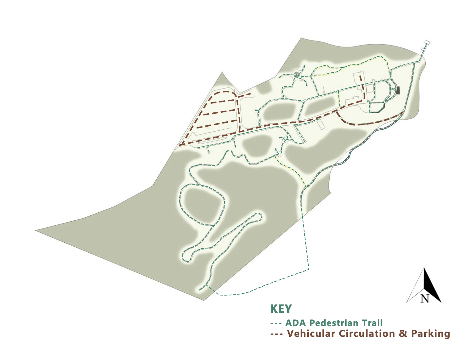
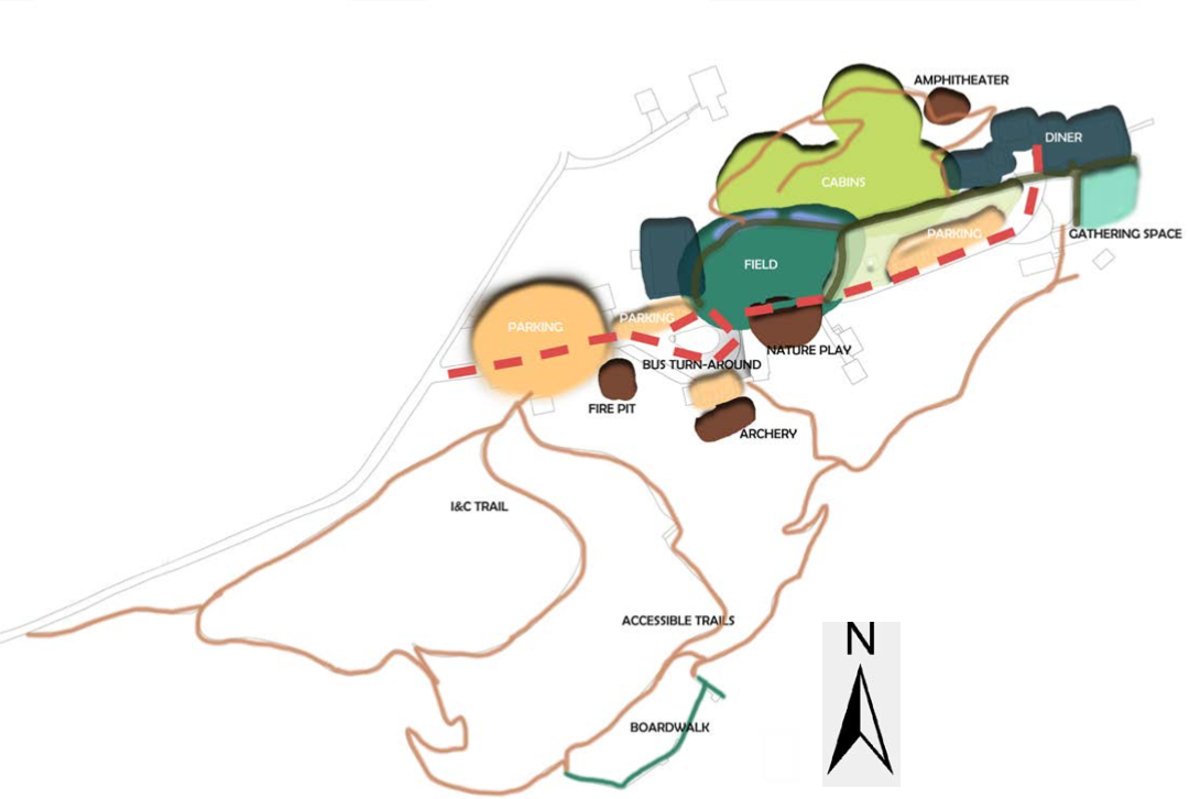
Functional and Circulation Diagrams
The functional diagram demonstrates the overall layout of the site. It gives a visual of where different areas such as recreation and trails are relative to the site. This diagram shows areas on the site that have been expanded or added. For example, the design implemented a larger parking lot in order to accommodate more vehicles. Several other parking spots were also integrated specifically made for employees only.
Several of these areas were added or moved to better fit the needs of the users. The fire pit was moved from the side of the Resource building and moved to an area where the wind will not affect the fire while the archery activities that occurred in this area moved to behind the portable building. Aside the pavilion, a nature play will be integrated to give the area a sense of life and enjoyment so that when the children are dropped off, they are welcomed by it.
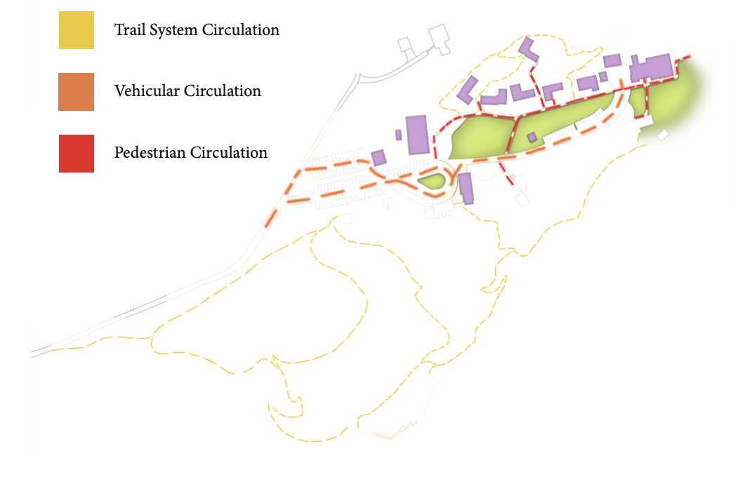
The circulation diagram outlines the main paths and routes for the trails, pedestrians, and vehicles. The trail system is outlined in yellow, the vehicle circulation in orange, and the pedestrian circulation in red
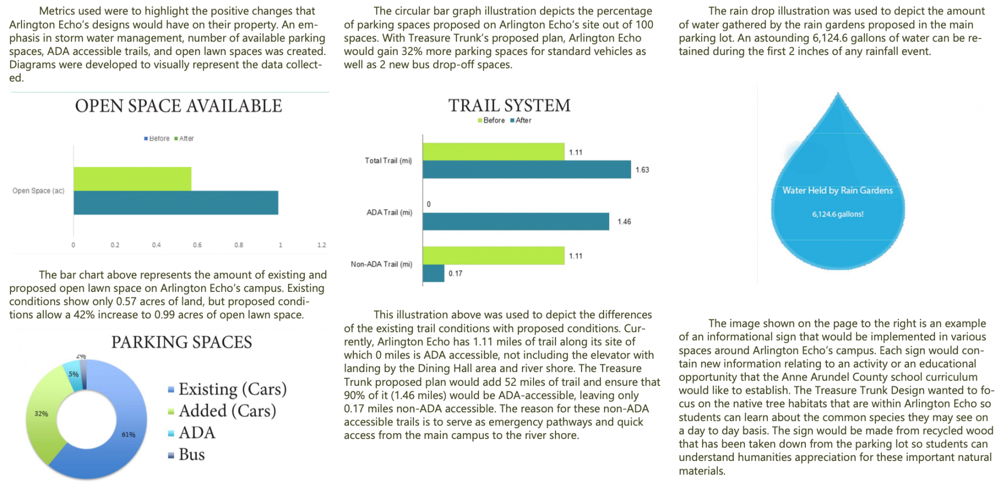
Performance Metrics
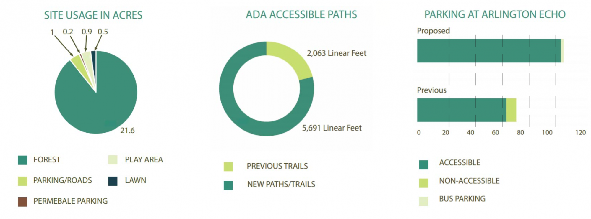
During consultations with members of Arlington Echo, there were concerns with parking, ADA accessibility, nature conservation and overall aesthetics of the site. These topics were taken into consideration while developing designs for the rejuvenation of Arlington Echo. In cases where applicable, there were implementations for permeable pavement, addition of native plants and stormwater management. With a large majority of the site composed of forest, application of forest conservation was critical in the design of the parking lot and roads, and the placement of elements.
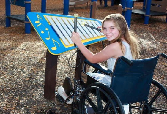
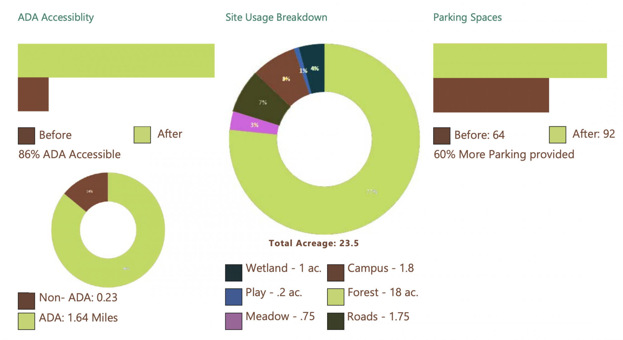
ADA accessibility was a necessary element of the site design, due to the fact that the site needs to accommodate children from Anne Arundel County schools regardless of physical capability. Trail ADA accessibility was also critical to the site design. By making all trails ADA accessible, the design enables people of all ages and capabilities to explore and enjoy the experience that Arlington Echo provides.
Parking at Arlington Echo was a major concern due to both safety and capacity limits. By increasing parking in the proposed design we are nearly doubling the number of spots on the current site. The proposed bus parking/ pull-off also helps enable proper circulation of the site while providing safe visitor drop offs. The proposed design has a total of 4 accessible parking spots located in various locations of the site.
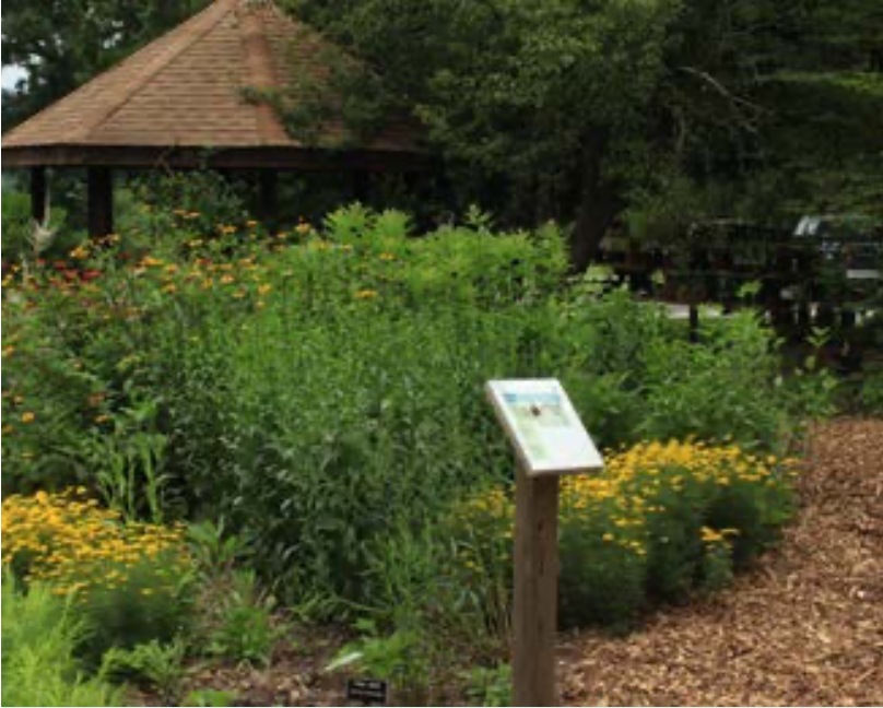
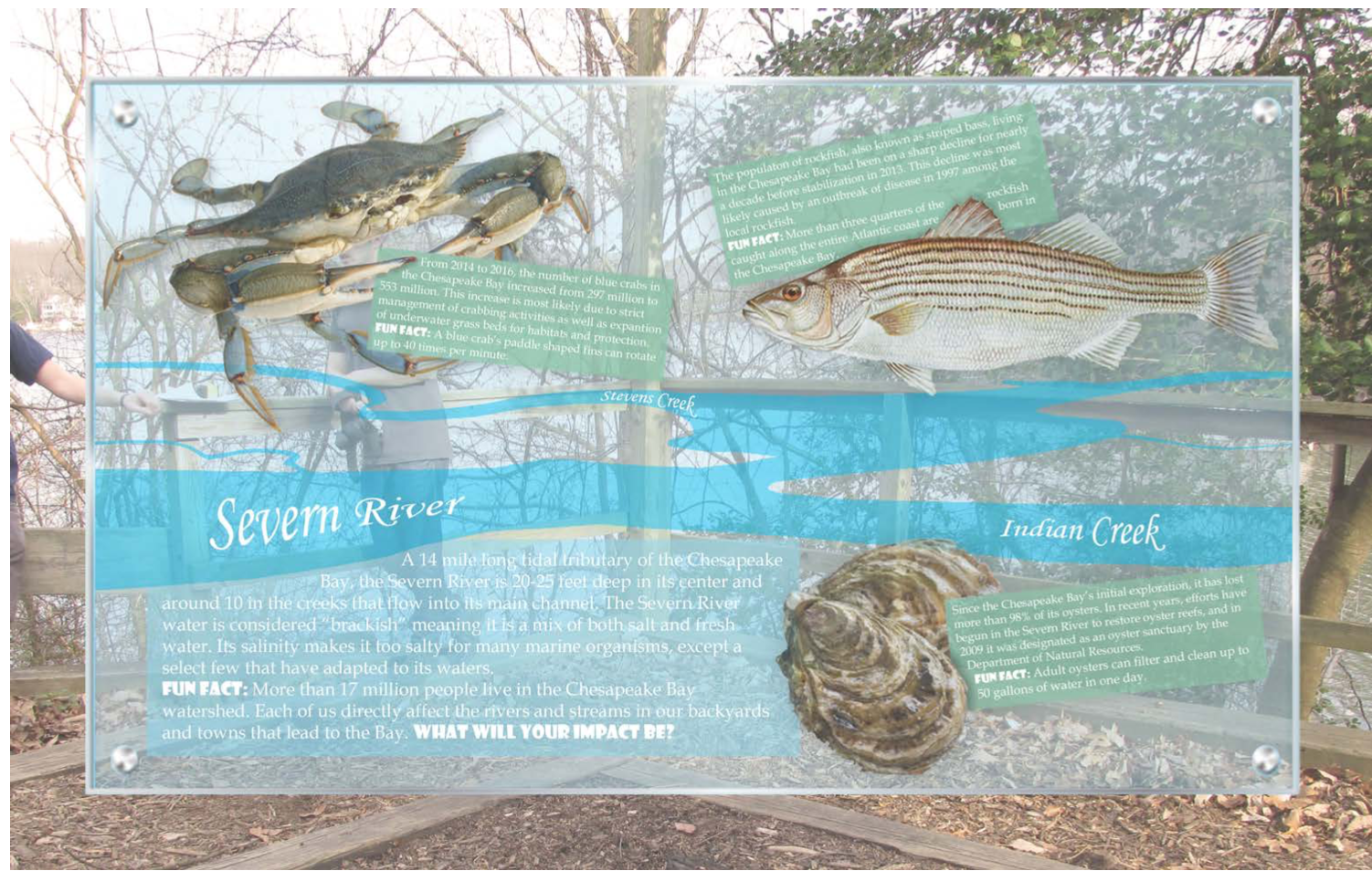
Interpretive Sign
Made of glass, this particular educational sign allows its viewer to peer through its face and see the names of the rivers reflected on the bodies of water themselves.
In addition to general information about the Severn River, the major body of water surrounding Arlington Echo, it depicts a few of the native organisms that inhabit these rivers, as well as the impact they have on the ecosystem.
Team 4
Nature does nothing uselessly.
Mission
Create a safe environment that accommodates people of all ages, abilities, and backgrounds, while maintaining the integrity and natural essence of Arlington Echo.
Objectives
- Develop ADA accessible trails throughout site.
- Provide adequate parking.
- Maintain the history and natural feel of Arlington Echo
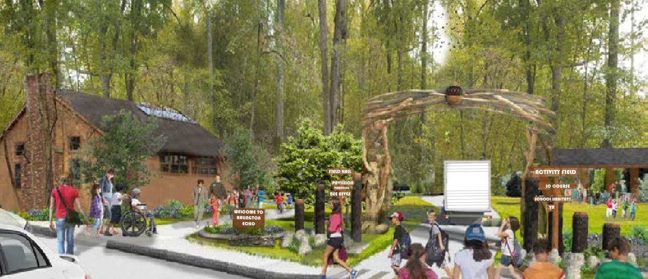
The theme developed for the design of this site is inspired by the Quercus rubra, commonly known as northern red oak. Following the site plan, one sees that the main road follows the form of a tree trunk, while the surrounding buildings and activity spaces allude to the branches and leaves of the tree canopy. The northern red oak is also known for the acorns it produces, that provide ecological benefits. As a result, the acorn symbol drives the new design of Arlington Echo, and is utilized throughout the site, beginning with the grand entrance.
As visitors drive through the front gates of Arlington Echo located on the western edge of the site, they are immediately immersed by oak trees. The two lane parking lot, consisting of 92 spaces and equipped with four accessible spots, and two bus spaces is reminiscent of a meadow. Tall grasses and rain gar- dens consisting of water loving plant species bring color, height, and stormwater management to the parking lot. Traveling east on the road, a high arch adorned with the monumental acorn symbol and welcome sign, signify the entrance to Arlington Echo.
Once visitors enter the site they will be surrounded by an array of activity spaces. These spaces range from open fields, a nature play area, and acorn shaped tree houses that are attached to the newly renovated research center.
Trails are located at both the northern and southern edges of the property and have been altered from their previous forms to become ADA accessible. These trails lead to different activity spaces located on the perimeter of the site including the marsh walk which has also been altered to be ADA accessible.
Every space incorporated into the site serves as an educational experience through which visitors can be guided by either an activity leader or educational signage strategically placed throughout the entirety of the site.
 |
 |
 |
 |
Parking
The main parking lot, located on the west side of the site, has been expanded to accommodate the increased amount of visitors to the outdoor center. The wood from the inevitable clearing of trees, has been recycled throughout the site in an effort to educate visitors about the importance of recycling. It also emphasizes and how art can visually improve and unify a site. The way the wood has been distributed on the site is becoming a characteristic of the design, and gives the outdoor education a strong identity.
A meadow has been planted in the bioswales that divide the rows and have several functions; screen parts of the cars, infiltrate and filter stormwater on site, expand the educational field, as well as enhancing wildlife on site through the native plantings.
Outdoor Education Center
At the entrance to the outdoor education center is an arch with an acorn symbol as the focal point, which invites visitors to enter into the nature center. The acorn has been given a central position, symbolizing the natural feel of the site and giving the outdoor education center a strong identity.
The entryway is an active space, meant to guide visitors in the right directions. Signage has therefore been provided in order to successfully do this.
The wooden arch, signs, and the acorn symbol are all made from the recycled wood taken from the trees that occupied the parking lot space.
To accommodate for more play on green lush grass, an additional field has been implemented. It is located in front of the orienteering pavilion, where the old bus drop-off used to be.
The lush grass field is lined by wood chips. This has been done to make the transition onto the field easier on the grass edges, and to visually unify the old field with the new. The wood chip edges also serve as a place to distribute damaged tree branches and materials that are found on the site.
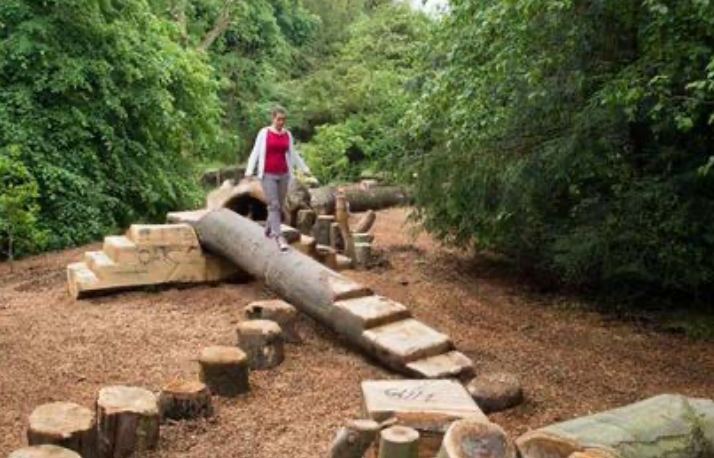
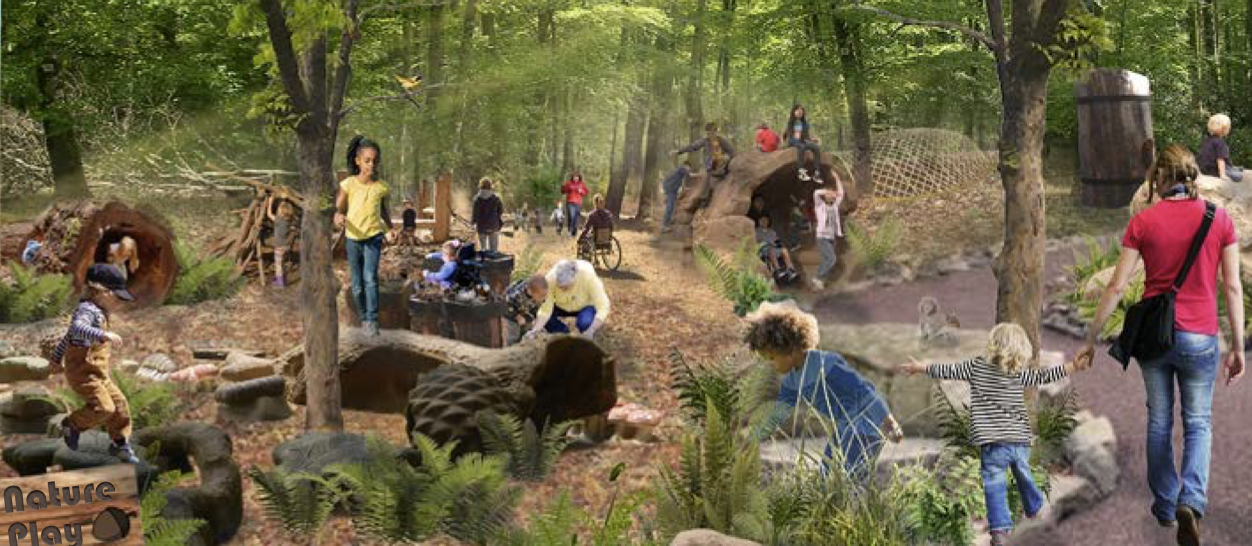
Nature Play Space
A nature play space has been added in the area between the pool and the pavilion. It is a central location and has some slight elevations for enhanced natural play. The proximity to the Field Hall and access to the parking lot makes this an ideal place to spend time.
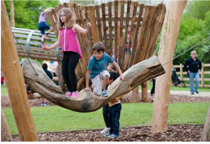
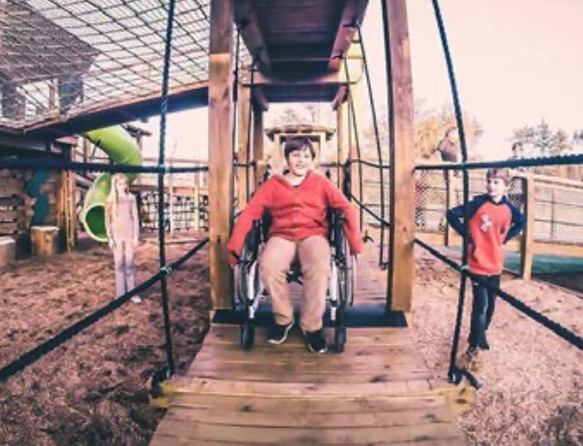
The nature play is targeted for children between ages 3 and 5, however, any age group is welcome. The nature play offers a range of play; from jumping on logs, climbing on stones, counting tree cones, and practicing building skills with sticks and branches. The area is adapted for ADA-usage.
The Initiative and Confidence Course (I & C Course) is located in the woods, to the right of the parking lot. New obstacles have been added in order to enhance the experience. Many of the obstacles are now also ADA friendly. These include the creative spiderweb obstacle, and the exciting elevated ramp obstacle.
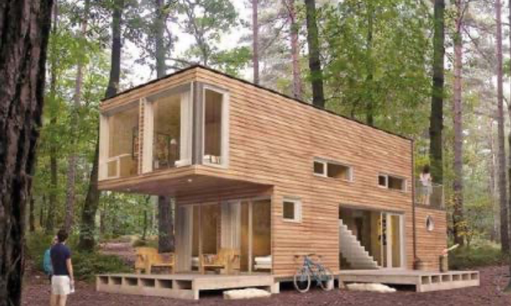
Net-Zero Building
At the far northwest part of the educational center, the Resource Lab has been replaced by a net-zero building. A net-zero building uses energy that can be produced from clean, renewable resources.
The space between the Dining Hall and the new Resource Lab has been redesigned to unify the space with the net-zero building, and to emphasize opportunities for gathering, such as for informational meetings. The existing bog has been expanded and beautified and extends deeper in to the space. Its location and size has turned it into a visual focal point that can be seen from many places on the site.
Behind the new net-zero Resource Lab, a tree-house has been installed in the lush tree canopies. The tree-house is shaped like an acorn to emphasize the theme and identity of the outdoor center further. This shape adds interest to the experience when being inside the tree-house.
The tree house is accessed through an elevated walkway, from the flat area outside the Resource Lab. The Resource Lab has a green roof, as well as a small hut for adults to easily supervise the area.
The tree-house is supported by posts attached to the ground, and offers a breathtaking view. One can see birds, wildlife, and investigate the lush canopies of the different tree species. The amazing overview of the marsh along the Severn River can also be enjoyed.
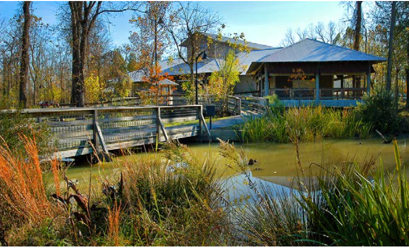
The Marsh Observation Walkway
The Marsh Observation Walkway is located in the south, along the Indian Creek Cove. The walkway has been modified to fit ADA- accessibility standards, with curbs on each side for safety measures. Additional plants have been add- ed for a richer experience and to contrast the grasses that now occupy most of the marsh.
A pavilion has been installed along the walkway to provide a place for resting and to protect from the sunlight during the warmer days. Seating is available under the pavilion, which is large enough to hold a class of 10-15 people.
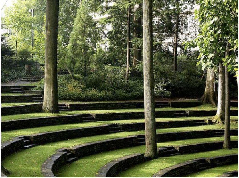
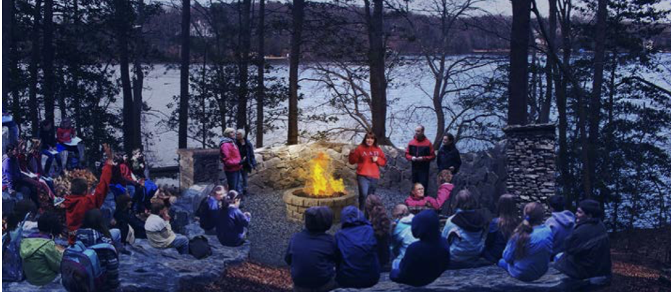
Amphitheater
The amphitheater located on the north slope of the site has been modified to accommodate a fireplace. The fireplace is set on gravel with adequate space around it
for safety. The trails that lead down to the amphitheater are ADA-accessible, allowing everyone an opportunity to take part of evening fun, grilling s’mores, and enjoying the beautiful view over the Severn River. A stone wall has been installed behind the fireplace for safety measures, and to protect against wind. The colors and rough surface of the stones also complement the view of the water.
The amphitheater can hold up to 106 people, and includes 4 landings to accommodate wheelchairs.
The seatings, which were previously wood, has been changed into stone, enhancing a more naturalistic feel of the space. The previous wood benches were also becoming dam- aged by rainfall and the lack of sun, which is not an issue for the stone seatings.
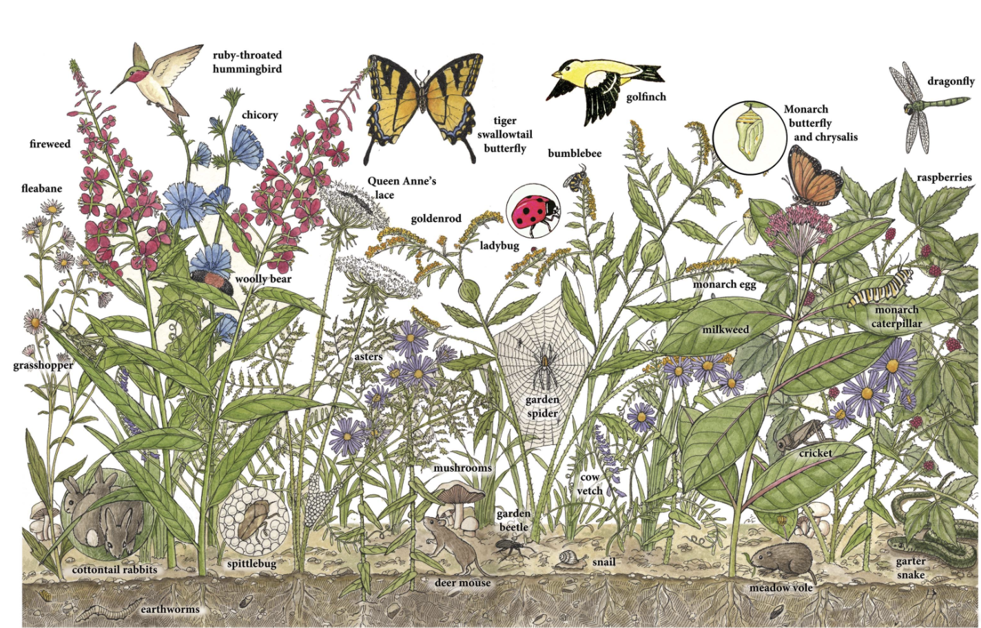
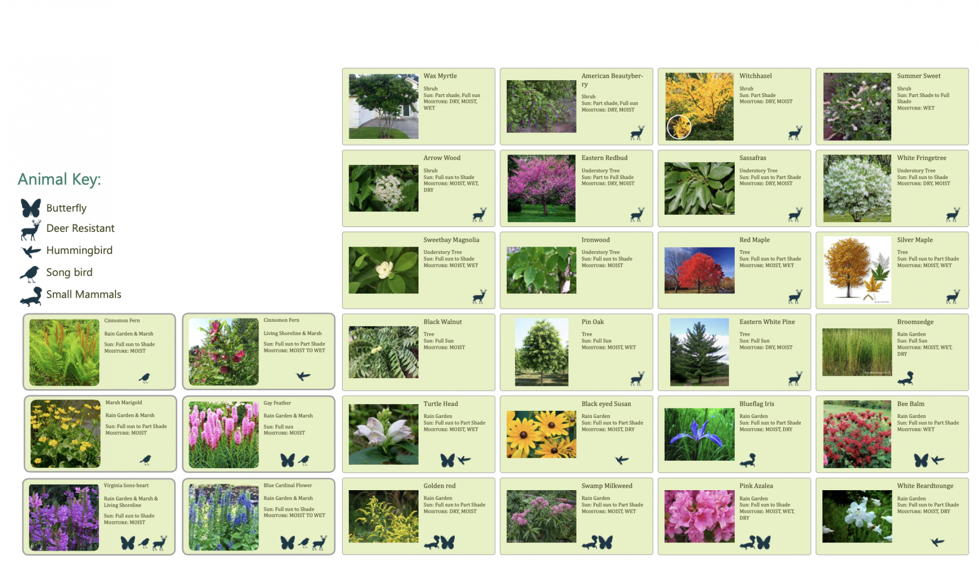
Plant Palette
The plant palette diagram shows the the native vegetation that may be planted in various locations throughout the site. This palette illustrates where each plant may best be suited to the local site conditions. This includes rain garden species, living shoreline species, and marsh vegetation. The palette shows representations of species that can be supported through these native plants.
Performance Metrics